The Hanwell Park Project
'THE COUNTRY OF THE HEART' - MORE IDEAS ON MAPPING
Back to Introduction and Contents
There's
more to maps than just finding your way from A to B, in fact almost
anything can be mapped if it's possible to envisage identities and
connections. I had a sense of this during some work at Farnborough when
I was trying to answer the question, 'Can Improvement be Fun ?'
A gloss was added to the plan of the Cascade and the associated
features. Partly, OK largely, tongue-in-cheek I wanted to express one
extremely speculative view of how the complex could have been
experienced by an eighteenth-century visitor, or rather pair of
visitors.
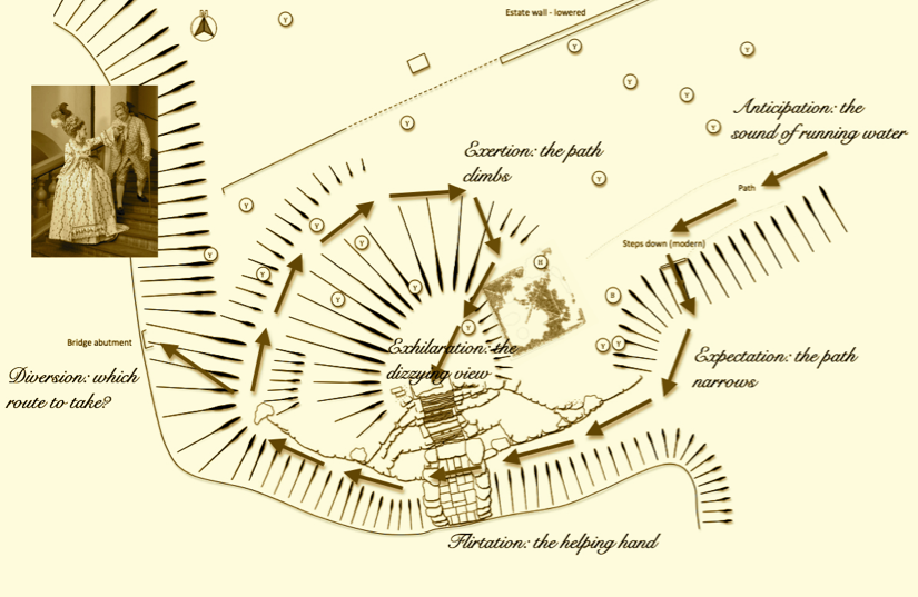
'The Lovers Plashed' - An Eighteenth-Century Comedy of Manners.
'The Lovers Plashed' - An Eighteenth-Century Comedy of Manners.
All good clean fun but then I read Penelope Gouk's paper Performance practice: music, medicine and natural philosophy in Interregnum Oxford.
Here's a key passage,
Now leaving aside the slightly unsettling phrase, 'it seems generally taken for granted' the rest of it and indeed the whole article makes a lot of sense. In reflecting on Oxford in the the 1650s she notes how musicians and those dedicated to then pursuit of natural science basically hung around together and that the spaces, the activities and the thoughts they shared were interconnected. We'll come back to this but my initial thoughts about connectedness at Hanwell began with the Cope family tree, it's useful to have it fairly clear who was related to who and in what order. This started to produce some useful in-sights but I realised that, with particular reference to the fourth Baronet, Sir Anthony - the Virtuoso, family connections would only take you so far. In the late 1650s he was playing host to such extraordinary figures as Thomas Baltzar and Richard Allestree so next up was another kind of map sometimes known, I believe, as a sociogram. Here is an early version.
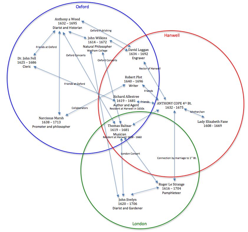
It's quite rudimentary and not particularly tidy but one begins to get a glimpse of who was likely to know who and in what kind of setting. Now modern studies of social networking can achieve all sorts of mathematical wonders and are able to describe any given population using terms such as homophily, multiplexity, reciprocity and propinquity. This all is based on an assumption that one has a fairly complete picture of the entire network, a situation which is unlikely to hold true in an historical context. Even so I'm sure it is an area which would merit further study... we'll see. So back in Oxford we could in theory map the built environment, the related social networks and the conceptual framework and superimpose them and it would look something like this.
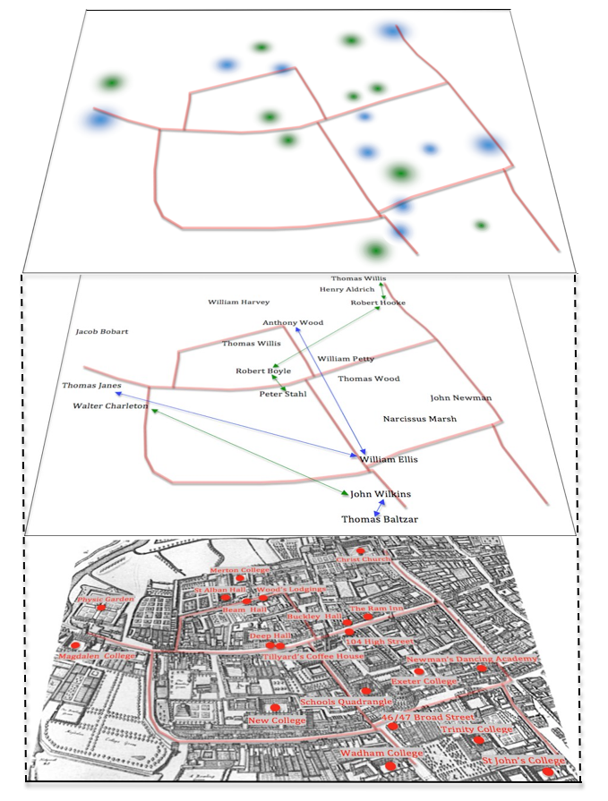
Multi-layered Oxford, science and music in the seventeenth century.
'it seems generally taken for granted that the
organization and construction of the cognitive world, the realm of
ideas, is directly affected by the way that the social and material
world is organized and constructed (and vice versa)." (Gouk 1996: 258).
Now leaving aside the slightly unsettling phrase, 'it seems generally taken for granted' the rest of it and indeed the whole article makes a lot of sense. In reflecting on Oxford in the the 1650s she notes how musicians and those dedicated to then pursuit of natural science basically hung around together and that the spaces, the activities and the thoughts they shared were interconnected. We'll come back to this but my initial thoughts about connectedness at Hanwell began with the Cope family tree, it's useful to have it fairly clear who was related to who and in what order. This started to produce some useful in-sights but I realised that, with particular reference to the fourth Baronet, Sir Anthony - the Virtuoso, family connections would only take you so far. In the late 1650s he was playing host to such extraordinary figures as Thomas Baltzar and Richard Allestree so next up was another kind of map sometimes known, I believe, as a sociogram. Here is an early version.
It's quite rudimentary and not particularly tidy but one begins to get a glimpse of who was likely to know who and in what kind of setting. Now modern studies of social networking can achieve all sorts of mathematical wonders and are able to describe any given population using terms such as homophily, multiplexity, reciprocity and propinquity. This all is based on an assumption that one has a fairly complete picture of the entire network, a situation which is unlikely to hold true in an historical context. Even so I'm sure it is an area which would merit further study... we'll see. So back in Oxford we could in theory map the built environment, the related social networks and the conceptual framework and superimpose them and it would look something like this.
Multi-layered Oxford, science and music in the seventeenth century.
I've
only put in a fraction of the social links in the middle portion of the
map, there are lots more and I guess that everyone knew everyone else
to a certain extent but more research would enable us to characterise
the nature and strength of particular relationships. In the top map the
coloured blobs indicate areas of intellectual activity; green for
science and blue for music. I'm not really sure what this amounts to at
present, at the moment it's little more than an interesting exercise.... all ideas and comments gratefully received.