Early Ecclesiastic Enclosures in Oxfordshire:
Prescote, Cropredy
| John Blair writing in his book "Anglo Saxon Oxfordshire" (Alan Sutton
Publications 1994) describes
a number of Anglo Saxon church based settlements which seem to exist
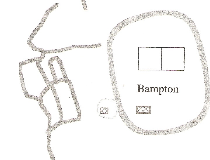
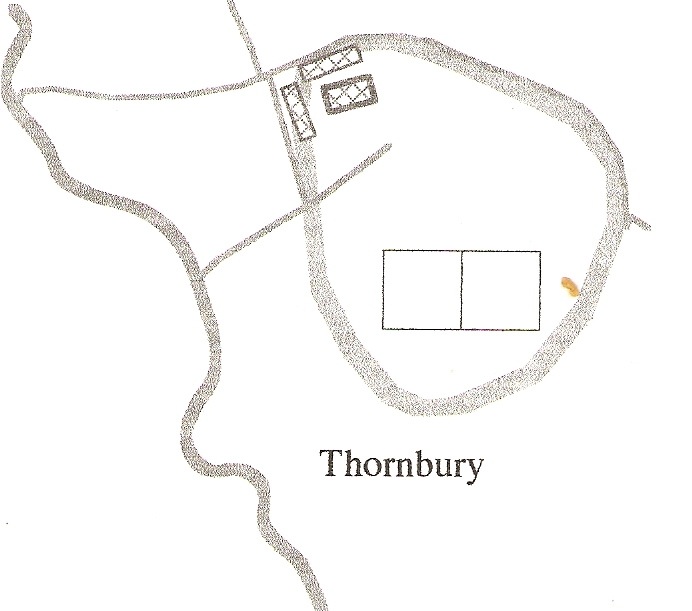
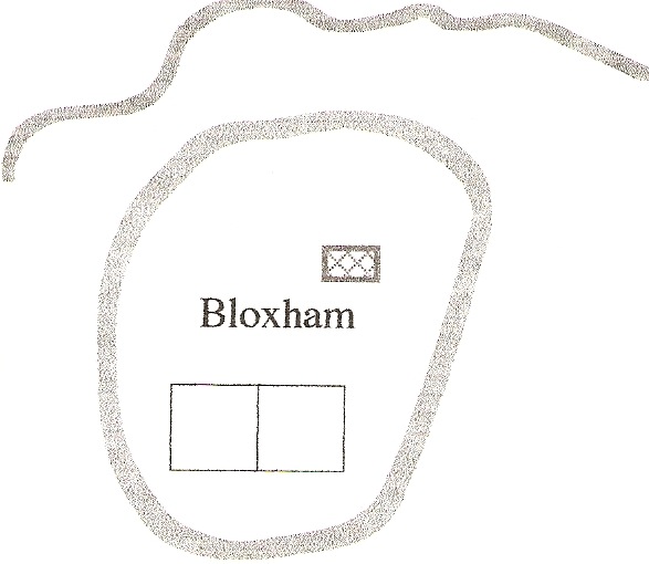
within roughly circular enclosures, specifically at Bampton, Binsey
(Thornbury) and Bloxham. In addition he points to the possible
significance of a large circular field next to the hamlet of Prescote
in the context of the legend of Saint Freomund of Cropredy, a tale
which he remarks is, "so bizarre and outrageous that it is worth
dwelling on."In 1997 as part of an 'A' level Archeology project I helped Rebecca Dealtry investigate
the site and make some comparisons with the other locations mentioned.
This work involved an earthwork survey of the remains of the medieval
village of Prescote and given that these remains have now (2010) been
ploughed over it seemed appropriate to make the record available on-line. |
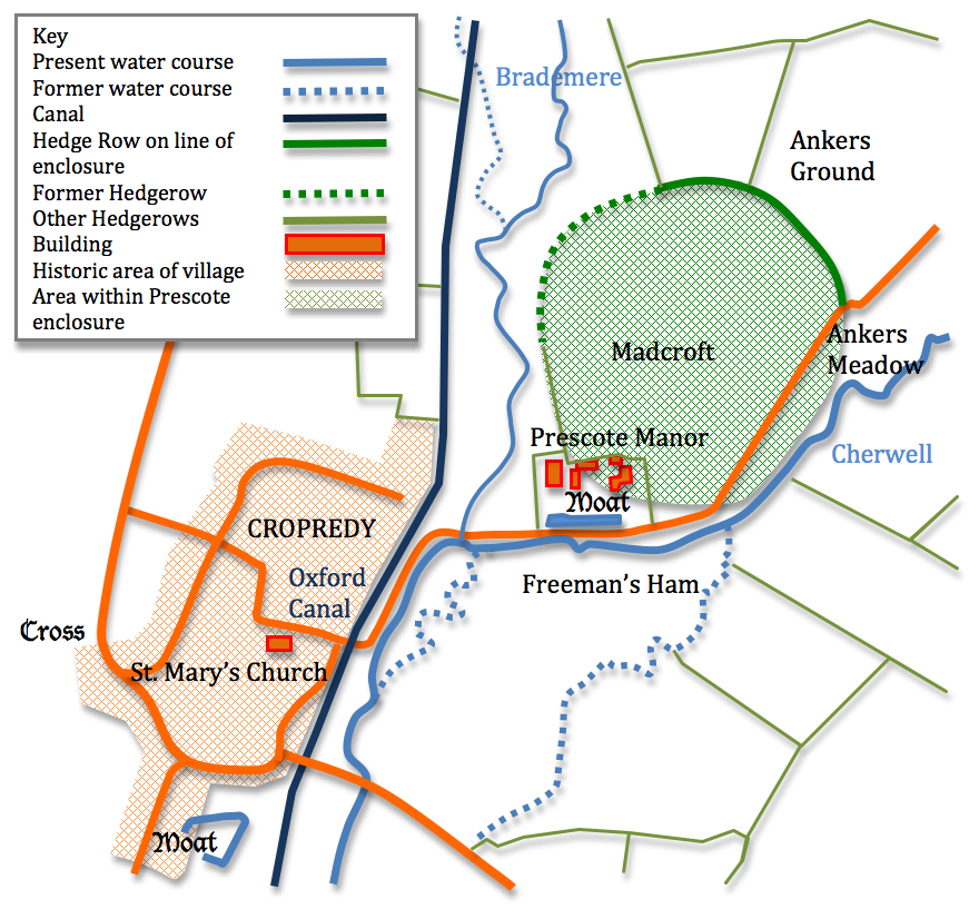
Professor Blair put the reference to the saint's reburial being "at a place surrounded by marsh inter Charewelle et Bradmere, where those rivers meet about three miles from Banbury." together with place name evidence from the surrounding fields to pinpoint Prescote as the location. The distinctive circular form of the field known as Madcroft prompts his comment that this is 'suggestive', suggestive of the circular form taken by a number of early Christian enclosed sites listed above and met with in other parts of the country. Ankers
Meadow and Ankers Ground may come from the term anchorite - a medieval
hermit, Freeman's Ham could be a contraction of Freomond and Prescote is of course Priest's Cottage. |
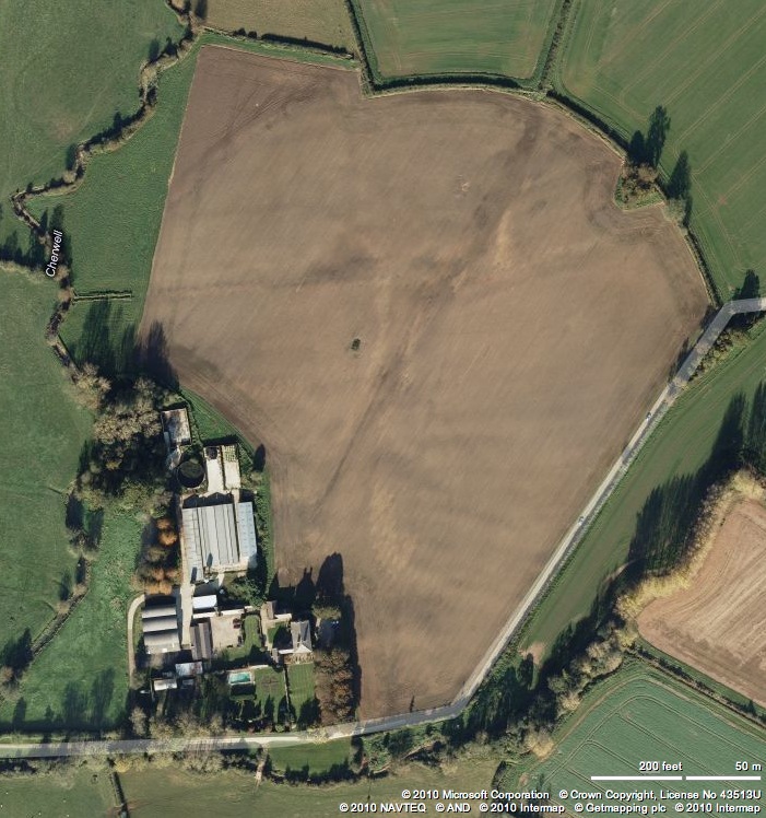 | 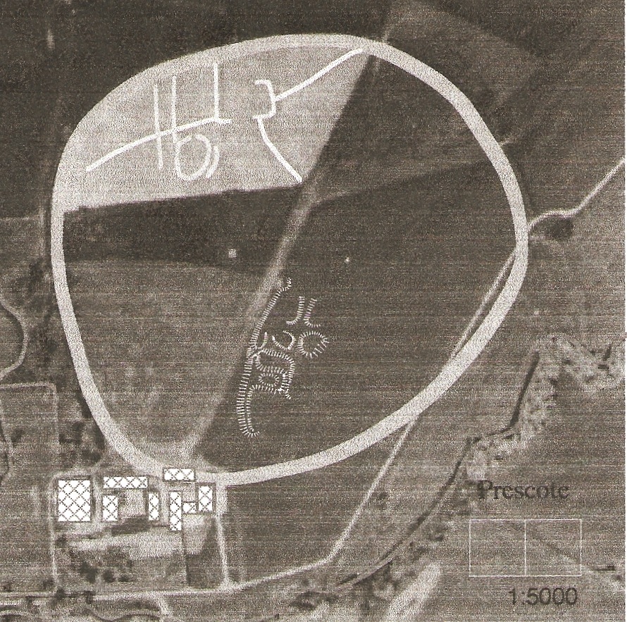 |  |
We began by examining an early aerial photograph that we believed to be from the early 1970s which we obtained from a local primary school. This showed roughly three quarters of the perimeter (from south-west through north to east) of a large ovoid enclosure, the interior divided radially into four unequal fields by hedges and ditches. This picture also showed a series of crop marks in the north west quadrant and faint traces of earthworks south of centre. We marked these of the photograph reproduced above (centre) and optimistically drew the complete circuit in the confident expectation that we would find the whole perimeter clearly visible, albeit in a degraded form, on the ground. When we made our first visit (courtesy of Ann Crossman who was the landowner at the time) we were disappointed to note that most of the perimeter hedge had been removed save for that portion between north and east and here there was no indication that this particular hedge line was any different from any of the other post enclosure hedges in the surrounding valley. Worse still was the fact that there was no surface indication of a major bank and ditch which we had hoped had demarked the site. The only feature indicating that such an enclosure had possibly existed was immediately to the east of Prescote Manor where there was a fairly well marked artificial terrace curving round for nearly 20 metres before being lost in what looked like surface quarrying. (See bottom section below) |
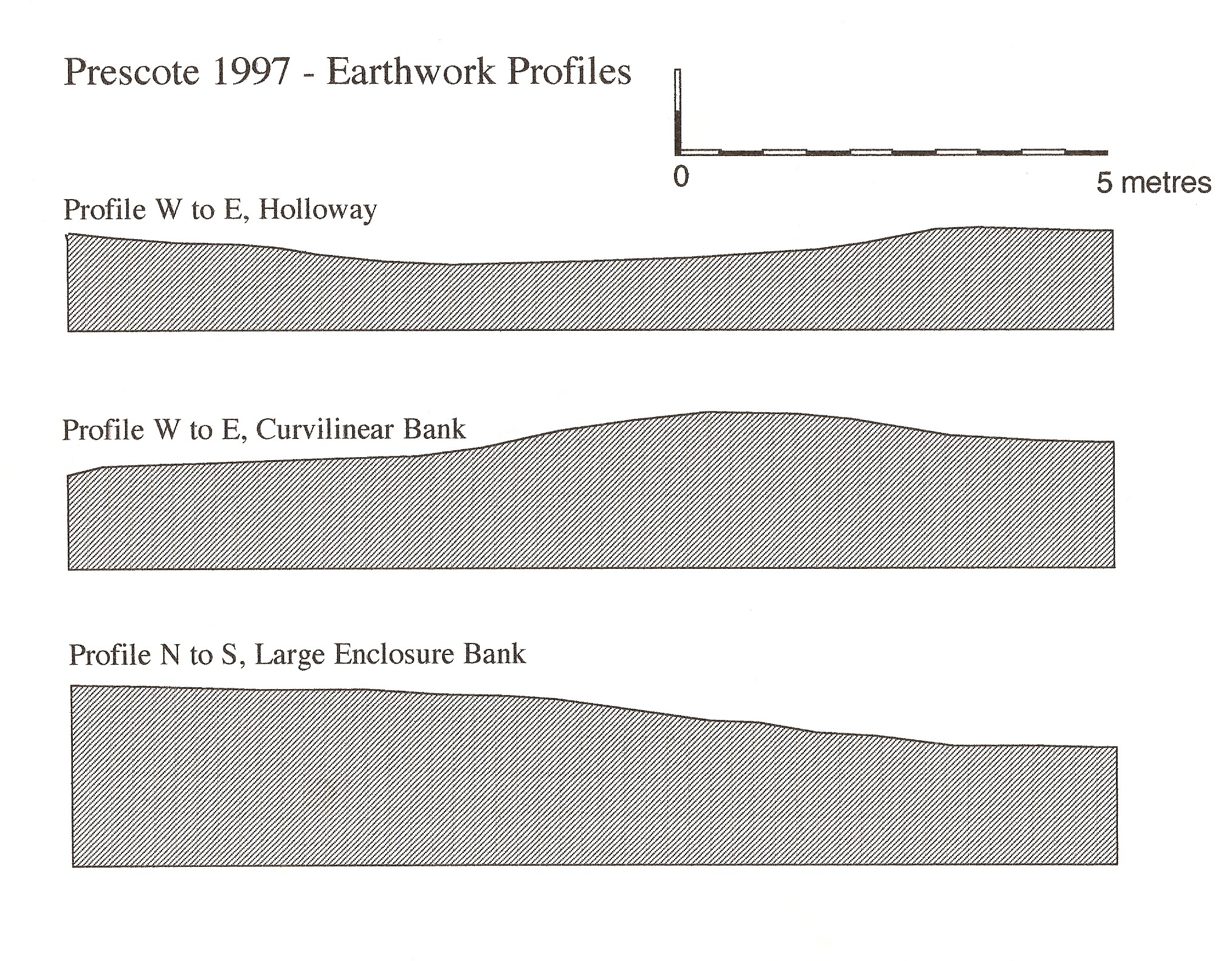
The interior was given over to pasture for grazing cattle but the field immediately to the north of the presumed enclosure - Ankers Ground, had been ploughed so we got set up to field walk it. Unfortunately again the results were extremely disappointing. Apart from a small amount of modern building debris the field appeared almost sterile in terms of finds. We did speculate at the time that the extremely hot dry weather we had been enjoying for the previous week or two had baked the ground in such a way that artifacts were masked by the dry dusty texture of the soil but even so it was puzzling to find so little. Things only began to look up a little when we cut across the interior of the area and found a series of quite pronounced and well preserved earthworks which had the typical features of a midland deserted medieval village (see plan below and sections above.) We surveyed these by triangulation from a base line using a pair of 30 metre tape measures and drew the sections by setting up a leveled line and measuring down to the ground surface at 0.5m intervals. |
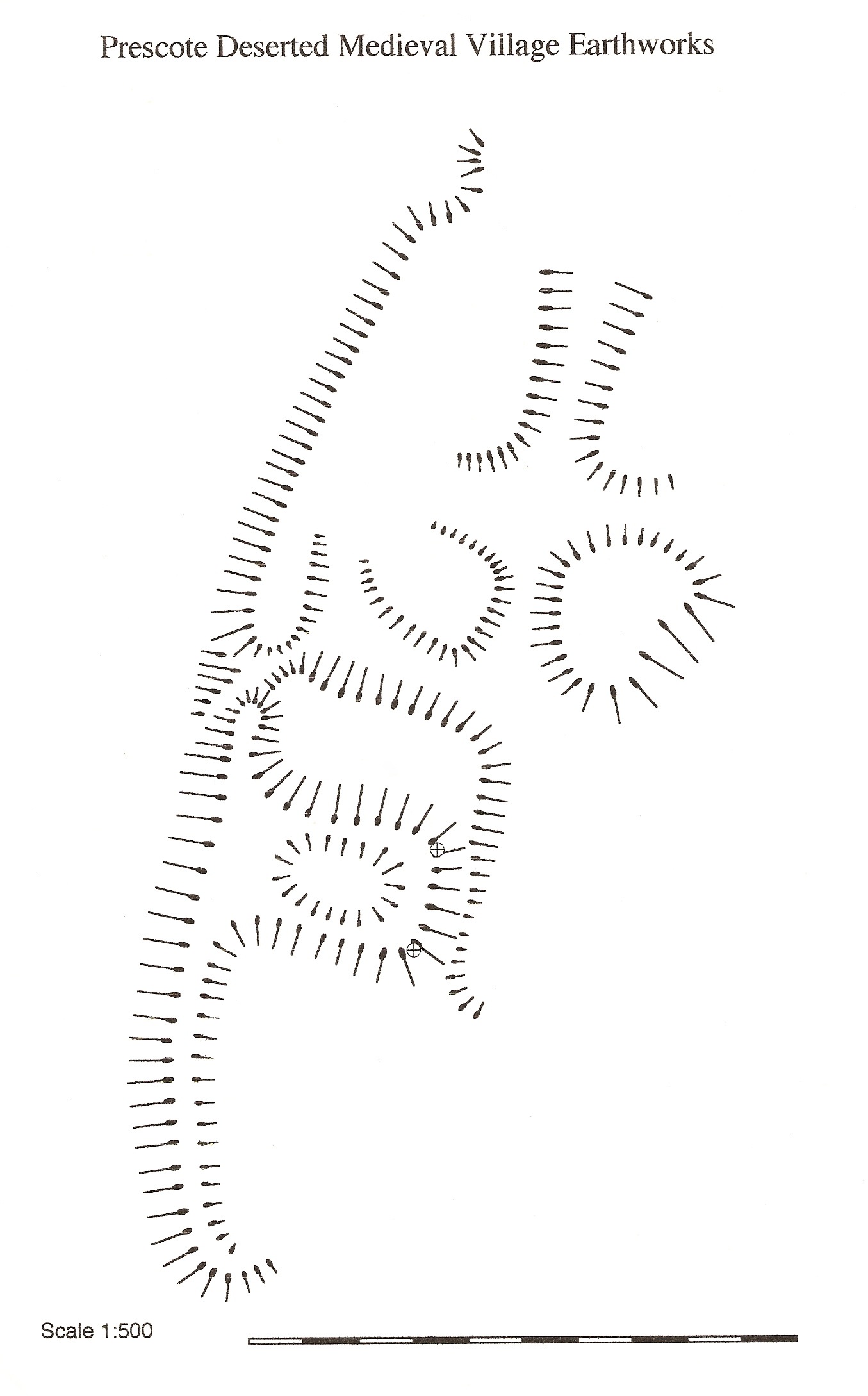
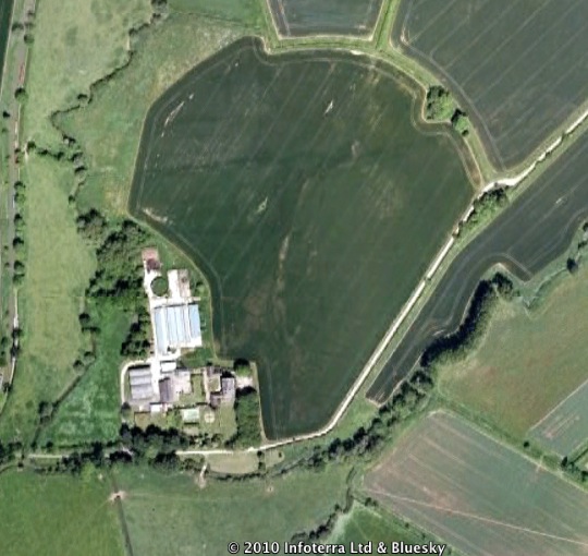
We identified four possible house platforms grouped around a holloway running north - south and to the south west of these a larger well marked house platform with earthwork indications of the line of a possible buried wall. The whole area of earthworks was bounded to the west by a low but well defined curving bank. the rest of the field was by no means level and featureless but it was impossible to identify any coherent features. Unfortunately when I walked out past Prescote a decade later the whole of the area we had examined was ploughed (see aerial views above) and whilst this could throw up further opportunities for field walking it has completely destroyed the earthwork remains on the medieval hamlet. What of our wider ambition to identify this as an early Christian enclosed site? Well the topographical evidence remains 'suggestive' As an exercise to investigate whether the field boundary could have come about simply as a response to geographical features, following a contour line for example to avoid excessively marshy ground, we systematically studied large scale Ordnance Survey maps for the Cherwell valley and tributaries as far south as Oxford. Although we found a few examples of field boundaries following contours - around the 155 m contour at Hobb's Hill Bloxham ( 424365) for example, we discovered nothing to parallel the curving line which ran inter Charewelle et Bradmere. The site clearly bears a strong topographical resemblance to the three locations mentioned by Professor Blair, sharing with them a close proximity to water and a link both physical and literary to the early church. On the other hand the possible Prescote enclosure is twice the size of those cited above. Hum... |
 |  |  |
The Legend of Saint Freomund - Adapted from Nova Legenda Anglie ed. by C. Horstman (1901) As collected by John of Tynemouth, John Capgrave, and others, and first printed, with New Lives, by Wynkyn de Worde a.d. mdxvi See the full text... in Latin here. Reputedly son of Offa of Mercia (king 757 to 796) Freomund had taken himself off to embrace the life of a hermit sailing from Caerleon with twelve companions to the island of Ilefaye - possibly Lundy, where they built themselves a chapel. Following the defeat and martyr's death of King Edmund in East Anglia at the hands of the Vikings the Mercians found themselves in need of a hero. As King Offa had died his son was recalled from his hermitage and placed in control of the army. This presumably did not go down too well with some of the established military leaders as one of his own troops beheaded him as he knelt in a prayer of thanksgiving. Notwithstanding this set back Freomond forgives his assailant, picks up his head and wanders off to a location between Harbury and Itchington (in Warwickshire) where a spring springs up. This is a case, by the way, of cephalophory or walking around without your head. Having washed his head Freomond evidently decides enough is enough and lays down and dies and which point a posse of friends and his now repentant murderer collects his body and takes it to Offchurch where it is buried in a lead coffin close to the royal palace there. As many people are aware, early medieval saints were notoriously unwilling to stay put in one place even when dead and buried so sixty six years later later three crippled virgins happen to passing by when they are struck by the sight of a column of light arising from the saint's burial place. This vision causes them to dig him up, under instruction by an angel naturally, and carry the coffin to 'a place surrounded by marsh between the Cherwell and the Bradmere, where those rivers meet, situated about three miles from Banbury...' or to put it more succinctly : "Corpus sanctum in locello plumbeo consignatum inuenientes, iussu angeli domini in loco quodam inter Charewelle, qui locus a Banneburi per tria fere miliaria distat et Brademere bitumine circundato vbi inuicem hii coniunguntur fluuii."Here he is laid to rest - as you may guess only temporarily -at a point indicated by a white carved stone. In order to add there own memorial the girls thrust a willow wand into the ground and the following morning they come along to find it grown into a full size tree - unless of course they had mistaken their place on the river bank. Whatever the case they were cured although whether of their crippledness or virginity is not made clear. Time goes by and the local peasantry who know holiness when they see it realise that hay made from grass mown from the immediate vicinity to the saint's grave cures sick animals. Meanwhile (This is Blair's connective and I just can't resist it.) in far distant Jerusalem a pilgrim by the name of Albert (Not the one who confronted the lion) was worshiping in the church of the Holy Sepulchre when an angel appeared. The angel instructed him to head for the place on the Cherwell where five priests shared a cottage and a precious treasure was buried beneath a willow tree. Alfred's immediate response is not recorded but obviously the angel has to try again. "Under one of the roots you will dig up a tomb... in which you will find the body of the holy martyr Freomund; under the same martyr's tomb you will find a sow with thirteen piglets, but you will not see how she comes in or goes out." Well this is enough to convince Albert and he heads back to Britain to track down the buried saint and the er... pigs. When he arrived all was as the angel had described and the word spread of the site's curative powers. Soon pilgrims were arriving from near and far to grab a cure. Obviously such a precious relic cannot simply be left lying around so it is decided to move the body to the nearest convenient monastery and St. Birinius from Dorchester arrives to lend a hand. The remains are loaded onto a cart and off they all set. However, the cortage has gone no further than a few hundred years when it all grinds to a halt and despite the efforts of a whole bevy of priests will move no further. Well what could they do except built a chapel here at Riddic (now known as Cropredy) and bury the saint - for the third time - in a shrine illuminated by silver lamps. Now knowing the locals as I do this sounds to be like an attempt by the residents of Cropredy to justify a bit of body snatching, after all, we all know how lucrative it is to have a saint's relics around to attract pilgrims and the like. But even this is not the end of the tale for in the early thirteenth century bits of him were removed to Dunstable Priory, however, something must have been left behind as the shrine in Cropredy church continued to be a focus for devotion until the sixteenth century. Of course it was all taken down at the time of the reformation and few people today know of its former existence. What strikes Blair about all this is not the extraordinary imaginative qualities of this story and others like it but," their strong sense of place... There is repeated reference to places and landscape features which the writers or their sources must have known." 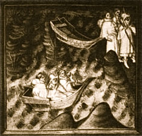 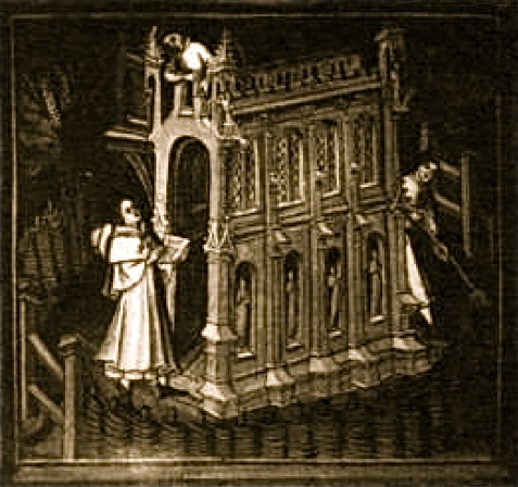 Freomund sails, possibly to Lundy Freomund builds a chapel The Victoria County History has a more measured approach to the whole story: "By the 13th century Cropredy was associated with the Mercian martyr St. Fremund. According to his legend, Fremund was a son of Offa of Mercia (d. 796), treacherously slain after a victory over the Danes c. 870. The connexion with the Danish invasion seems more probable than that with Offa, so that Fremund, if he existed, should be dated to the mid 9th century. The legend does not connect him with Cropredy during his life-time, but says that some years after his death his body was carried from its original burial place at Offchurch (Offa's church) to a plain between the Cherwell and the Brademere, almost certainly the Highfurlong Brook which separates Cropredy from Prescote. Here it was reburied and lost for some years before being rediscovered and moved to 'Ridic' where a church was built to receive it. Finally, probably by 1207, some of the relics were moved to the new Dunstable Priory. The plain between the Cherwell and the Brademere can fairly safely be identified with Prescote, and although the etymological evidence is not strong, 'Ridic' is probably Cropredy where the saint later had a shrine. In 1488 Richard Danvers of Prescote left 20s. to the chapel and shrine of St. Fremund, and in 1539 his daughter-in-law, Anne Danvers, left 10 ewes to the chapel of St. Fremund in Cropredy. No other place, apart from Dunstable, is associated with the saint. The legend does not, however, throw much light on the early history of Cropredy. If Fremund's connexion with Offa and the related story of his initial burial at Offchurch are discounted, there remains the tradition of a local saint, probably a hermit, who was killed or murdered during the Danish invasions and buried at Prescote, which was then apparently uninhabited. When miracles were reported, the body was removed, probably to Cropredy, and a shrine built for it." |
v
In 1086 there were five mills in Cropredy parish, two in the Bishop of Lincoln's demesne and three in the hands of his tenants. (fn. 212) In 1968 there were still five mill cuts along the Cherwell within the bounds of the ancient parish, though that which supplied Cropredy Upper Mill had recently been filled in. They may represent the sites of the five Domesday mills. The two demesne mills may be assigned to Cropredy township, where the bishop had two mills in 1279 and 1441. (fn. 213) Walter the miller held a yardland of the bishop in Cropredy c. 1225; (fn. 214) William at the mill of Cropredy was hanged in 1315. (fn. 215) Two mills formerly belonging to the episcopal demesne in Cropredy are mentioned in 1552, 1589, 1596, and 1606, (fn. 216) and the Upper Mill at Cropredy was leased to Richard Gostelow of Prescote in 1621. (fn. 217) The two mills of 1552–1606 are probably those mentioned in 1664. (fn. 218) Upper Mill, north of Cropredy Bridge, was sold by Sir William Boothby in 1673, (fn. 219) but seems to have gone out of use fairly soon thereafter, for in 1719 and 1774 only one mill is mentioned; (fn. 220) in 1803 the site passed to the Prescote estate. |