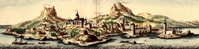
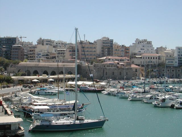
Heraklion
became one of the largest and most heavily defended cities in the
Mediterranean but its origins are uncertain. There are scattered
remains of Minoan settlement in the area and there may have been a
small town and harbour on the site in classical and early Byzantine
times. However, the town did not really take off until after the Arab
conquest of the island between 824 and 828 under the command of the
Saracen Abu Hafs Omar. Heraklion became the chief town of the island and
was used as a base for pirate raids across the Aegean. The town was
defended by a brick wall on stone foundations and further protected by
a wide ditch (Khandaq in Arabic) which lead to the town being renamed
Chandakas in Greek and Candia in Latin.
Crete
was retaken for the Byzantine Empire by the general, Nicephorus Phocas
in 961 and the devastated walls rebuilt. Chandakas became the largest
town on the island. The Fourth Crusade in 1204 and the fall of
Constantinople lead to Crete being ceded to the leader of the
Crusaders, Boniface of Montferrat, who sold the island on to Dandolo,
the Doge of Venice. The Venetians established control by 1211 and
developed the city to the point where it was viewed as second in
splendour and prosperity only to Venice itself. The growth of the town
lead to work beginning on a new set of walls in 1462 when the Venetian
senate, aware of the growing threat of the Ottoman Empire, ordered the
refortification of the city and its harbour. Local labour was
conscripted in on this huge project which occupied much of the
following century. In 1532 the Venetian engineer Michele Sanmicheli
arrived on Crete having previously worked on the fortifications
of Padua and Verona.
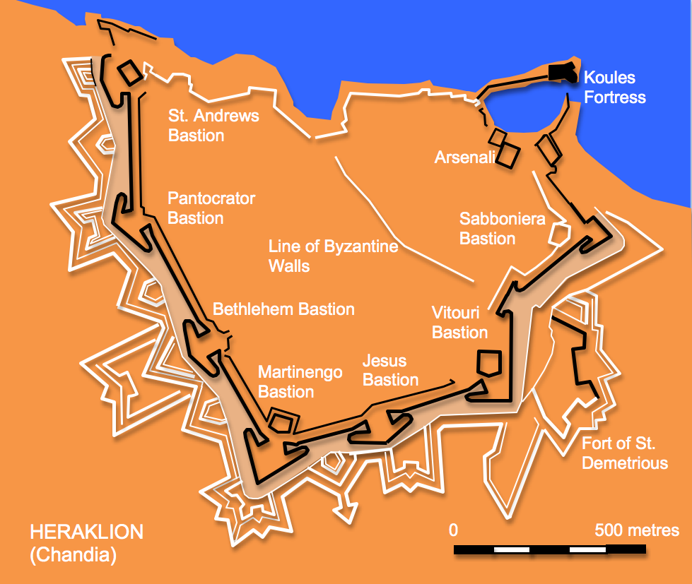
By the end of the 16th. century the town
was
defended by a huge circuit of walls with a perimeter of four and a half
kilometres. The massive nature of the construction meant that in places
the walls are 40 metres thick. The circuit boasted seven enormous
bastions with broad fronts and deeply recessed flanks and five city
gates. Additionally on a small hill immediately to the east
of
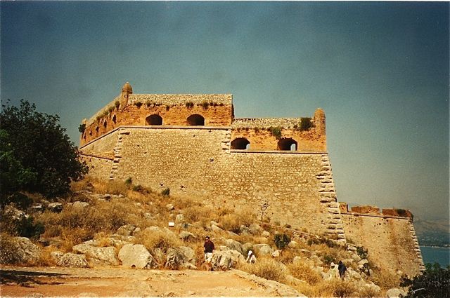
the town the detached Fort of St. Demetrius was erected consisting of a
trace with a small central bastion flanked by two demi-bastions. A
detached fort was built between 1523 and 1540 to protect the harbour. Known
as the Koules Fortress or the Rocca al Mare this rectangular
building has a large curved bastion overlooking the harbour entrance.
In a final phase of building the works were extended into the
countryside beyond the town with a series of detached ravelins, three
hornworks: two protecting the western wall and one in front of the
Jesus Bastion, and a crownwork to strengthen the Martinengo Bastion on
the south west corner of the town.
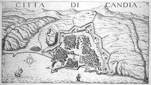
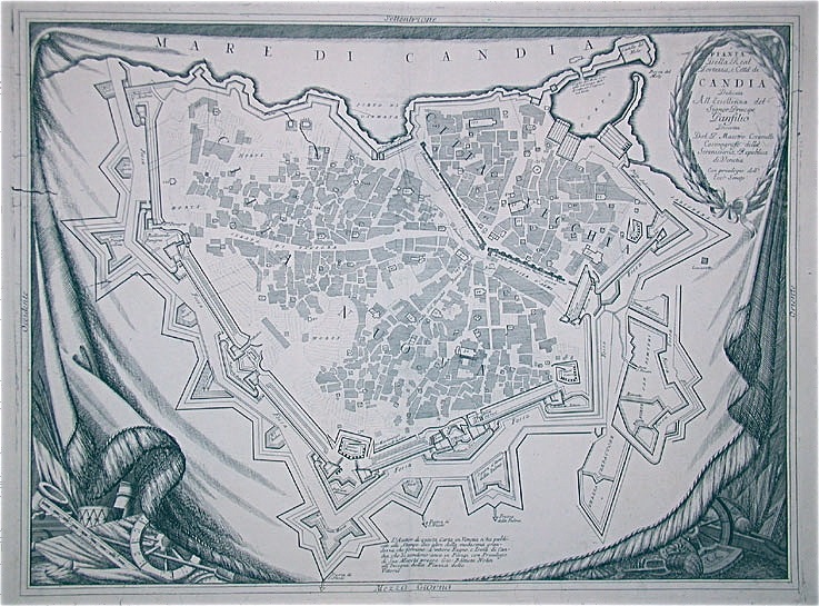
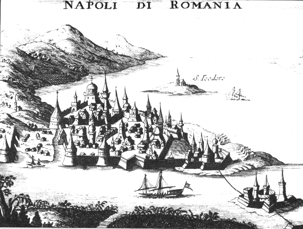
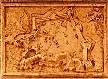
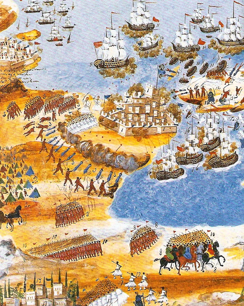
Boschini plan of 1651
In
1645 a Turkish fleet landed an invasion force in Western Crete which
progressively took over the entire island except for Heraklion which
was first invested in May of 1648. The siege continued for the next 21
years before being pressed to completion. In 1667 a Venetian
military engineer Colonel Andrea Barozzi defected to the Turks and
described to them the weak spots in the town’s defences especially
where they met the coast at St. Andrew’s Bastion on the west and the
Sabbionara Bastion to the east. A further blow came in 1669, when a
French expedition failed to lift the siege and lost
the
fleet's vice-flagship in an accidental explosion. Following these
setbacks the French abandoned Candia leaving General Francesco Morosini
with a much reduced garrison and limited supplies. He surrendered the
town on September 27th. 1669. The Turks repaired the town’s defences
but added few further improvements as the place became something of a
provincial backwater. The walls were seriously damaged by German
bombardments during the Second World War but have since, especially in
the last fifteen years, been heavily restored.
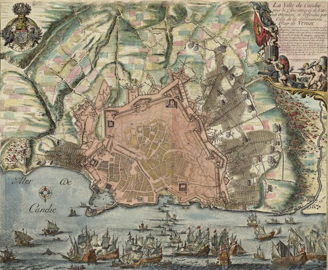
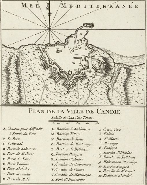
De Fer 1669 Plan showing Turkish Siege Works
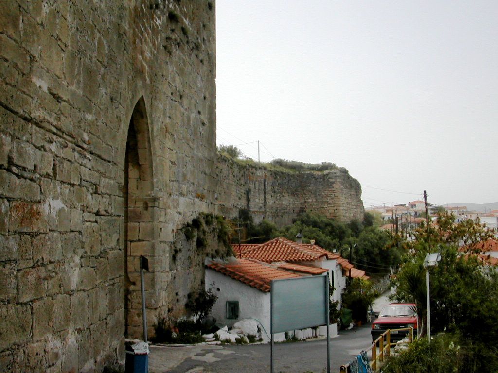
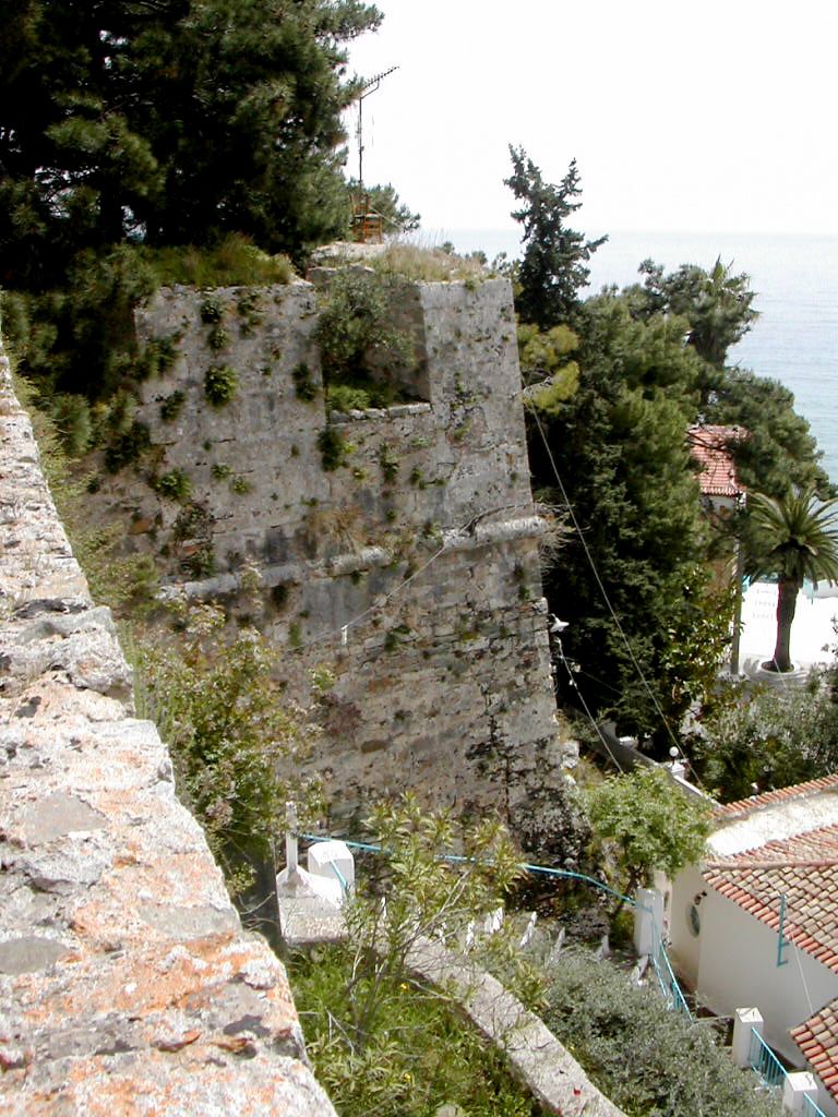
Visiting Heraklion
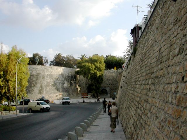
Heraklion
today (2007) is a big bustling city with extensive modern development
beyond the line of the walls and a massive traffic problem within them.
Walking the entire circuit of the walls is perfectly possible
but
given their length can be quite grueling in the heat of summer. Work
continues to repair and restore the walls, especially along the west
side and as a result much of the area has a rather raw and
unfinished feel to it and can be particularly dry and dusty. Starting
at St. Andrew’s Bastion it is possible to follow a footpath along the
top of the wall to the Pantocrator Bastion.
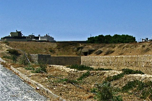
Restored
section of St. Andrew's Bastion
Bethlehem Bastion from N
Crossing
over the top of the largely modern Bethlehem Gate the path continues on
to the Bethlehem Bastion rewarding the traveler with contrasting views
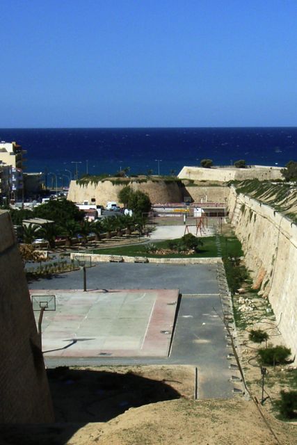
across the old town and the modern concrete suburbs. Much of the line
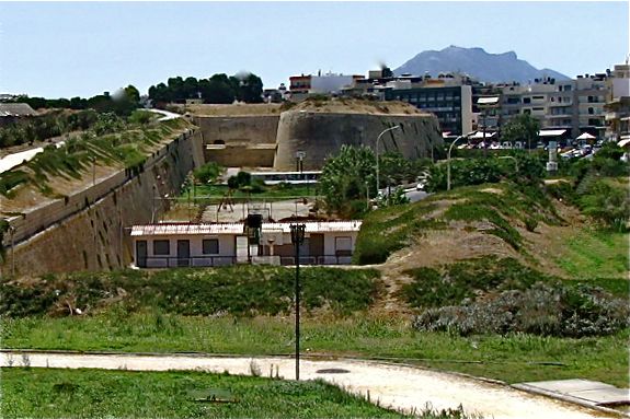
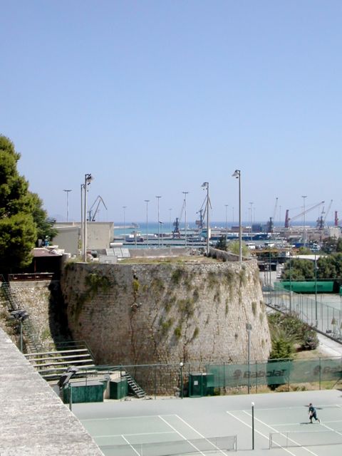
of the moat along here is taken up by public sports facilities. The
huge Martinengo Bastion contains a football pitch and in the well
preserved cavalier is the tomb of the Cretan writer Nikos Kazantzakis.
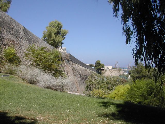
Beyond this point the area around the walls is quite heavily planted
which makes the environment much pleasanter but getting a good view of
the walls becomes increasingly difficult. Heading east takes us towards
the Jesus Bastion and beyond that the Vitouri Bastion with its very
overgrown cavalier. Leaving the line of the walls and threading our way
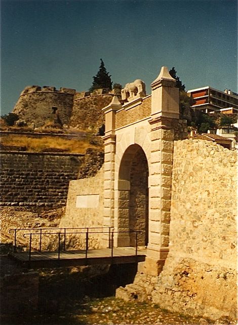
eastwards we eventually come to the restored St. George's Gate.
Curtain
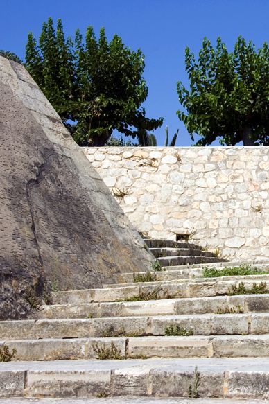
and St. Andrew's Bastion looking N
Steps to
Martinengo Cavalier
Sabboniera Bastion from SW
View
towards St. George's Gate
SE curtain wall
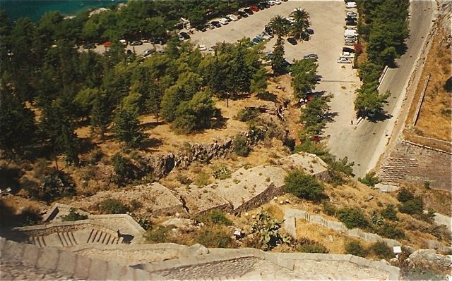
Beyond
this, around 200 metres further east are the considerable remains of
the stone faced ramparts of the Fort of St. Demetrious which begins in
Archimidous Street. Back on the top of the wall we walk past the rear
of the Archaeological Museum towards the Sabboniera Bastion, now taken
up by a school and its playground. The walk can now be directed down
towards the harbour past the huge ruinous Venetian Arsenali or ship
sheds towards the Koules Fortress on the end of its breakwater. There
is an admission charge and opening hours, from Monday to Saturday 8.00
a.m. to 4.00 p.m. and 10.00 a.m. to 3.00 p.m. on Sunday. The interior
of the fort is well preserved and amply repays careful examination.
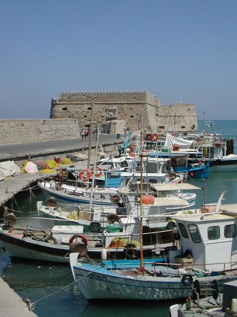
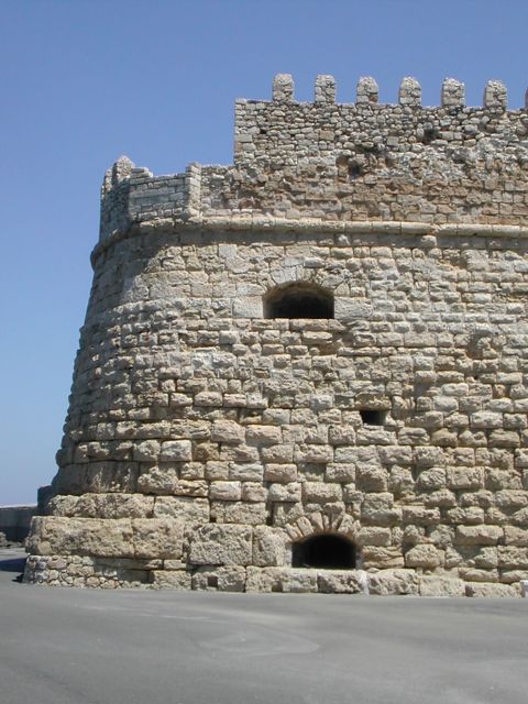
Koules
Fortress from SW
Venetiam
Arsenali from N
Koules Fortress
detail of NW corner
Finally
the story of the town and its defences is admirably told in the
Historical Museum at 27 Sofokli Venizelou Avenue, about 350 metres west
of the harbour on the coast road, open Monday to Saturday, from 9.00
a.m. to 5.00 p.m. closed on Sundays and holidays. It is a remarkably
pleasant alternative to endlessly congested Archaeological Museum!
Relief sculpture from the
facade of Santa Maria Zobenigo in Venice
Coronelli
1689
Bellini 1764
N Curtain, gate and NE
Bastion from N
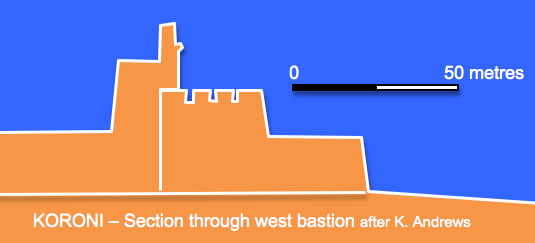
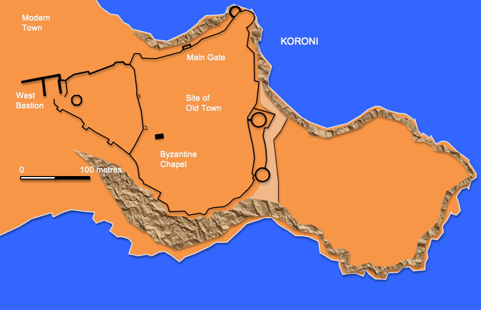
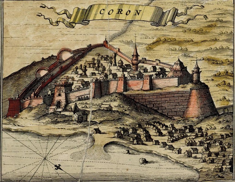
The
modern town of Koroni was founded in the 9th century on the site of the
ancient city of Assine. The remains of the classical temple to Apollo
can still be seen on the highest point of the headland, the
ruins intermingled
with an early Christian basilica and a small Byzantine
Church. In 1205 the town was captured by the Franks but they
in
their turn were expelled by the Venetians in 1207 who set about
strengthening the walls. The town together with Methoni became a vital
link in the chain of defended harbours which sustained Venetian trading
and commerce.
Drawing
by De Witt 1680
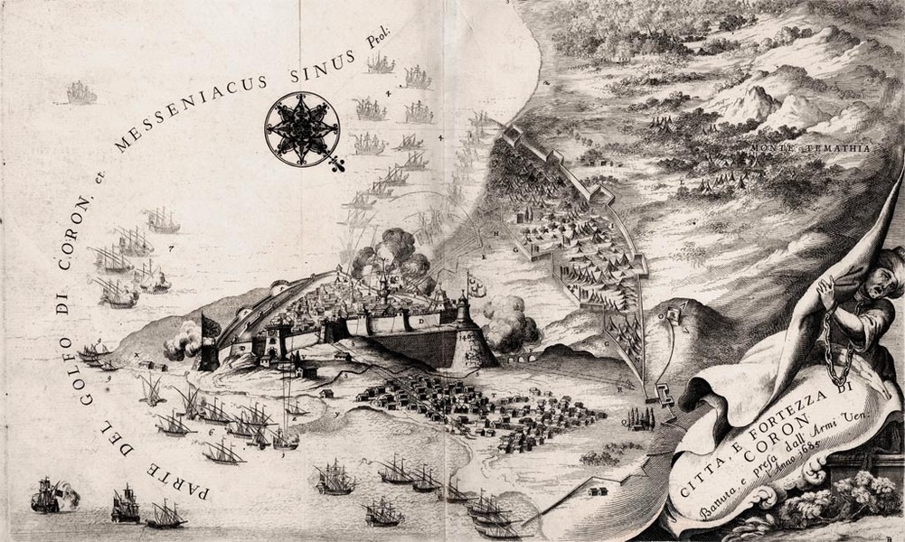
Siege of 1685
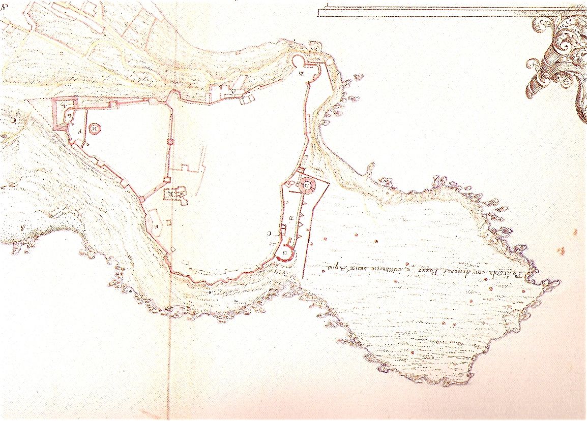
Venetian plan from Grimani
Portfolio 1700
Following
the capture of Methoni in 1500 and the subsequent massacre of its
defenders the local population were unwilling to mount a defence and
abandoned the town. In 1532 the Genoese admiral Andrea Doria assaulted
the town at the behest of the Holy Roman Emperor Charles V but was only
able to hold it for 2 years before it was retaken by Turkish forces. Both maps indicate a double line The fortress
fell after a two parallel galleries packed with 250 barrels of
gunpowder had been used to blow up the massive western bastion. The
fortress returned to Turkish control when Venetian forces pulled out in
1715. Following the Greek uprising of 1821 the Greeks attacked the town
but were unsuccessful in taking it. The fort was eventually surrendered
together with Pylos and Methoni to the French general Maison in 1828.
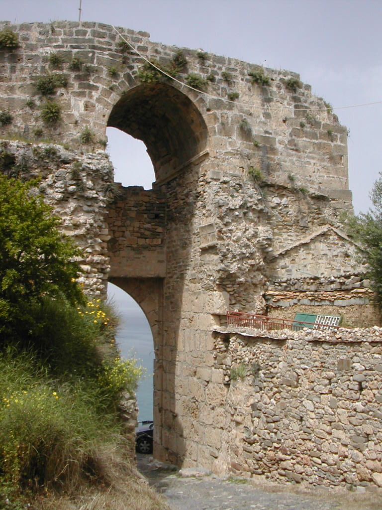
Interior
of N gate
N gate
and curtain looking W
Square tower on S
curtain
W
Bastion from NE
Repairs to E curtain
Terrace and SE bastion from N
It
is possible to reach the southern curtain beyond the adjacent
churchyard to enjoy striking views of the square towers set above a
massive sloping talus to the west before turning to the east and
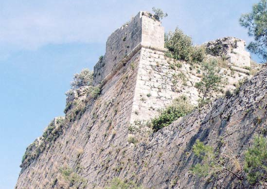
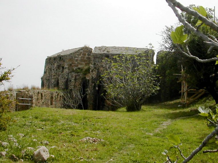
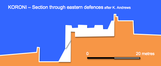
following the wall along the cliff top towards the eastern defences.
These consist of four massive circular artillery towers in a north
south line cutting across the headland. The southern most two are
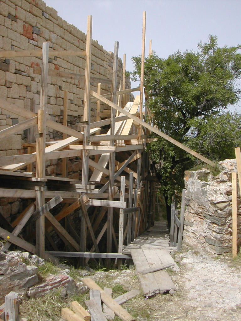
linked by a double wall and terrace with an outer moat. Considerable
restoration work is underway here (2008), the central bastion was badly
damaged by an explosion during World War II. The southernmost tower
encloses a single huge chamber with the roof being supported by a
central octagonal pillar 11 metres high. The chamber contains four
casements at floor level covering the approach to the harbour whilst
there are five further emplacements on the roof. At the north east
corner are two linked circular bastions at different levels containing
embrasures and musket loops.
Bibliography:
Castles of the Morea by Kevin
Andrews, Revised Edition, Princetown 2006
Venetians and Kinghts
Hospitallers – Military Architecture Networks, by Archi-med
Pilot Action, Athens 2002
Pylos – Pyla – A Journey
Through Space and Time by G. and T. Papthanassopoulos, Athens 2002
Fortresses and Castles of
Greece, Volume 2 by A. Paradissis, Athens 1994
Crusader castles in Cyprus,
Greece and the Aegean 1191 – 1571 by David Nicolle, Osprey Publishing,
London 2007
Venetian
Fortresses in Greece at: http://romeartlover.tripod.com/Venezia.html
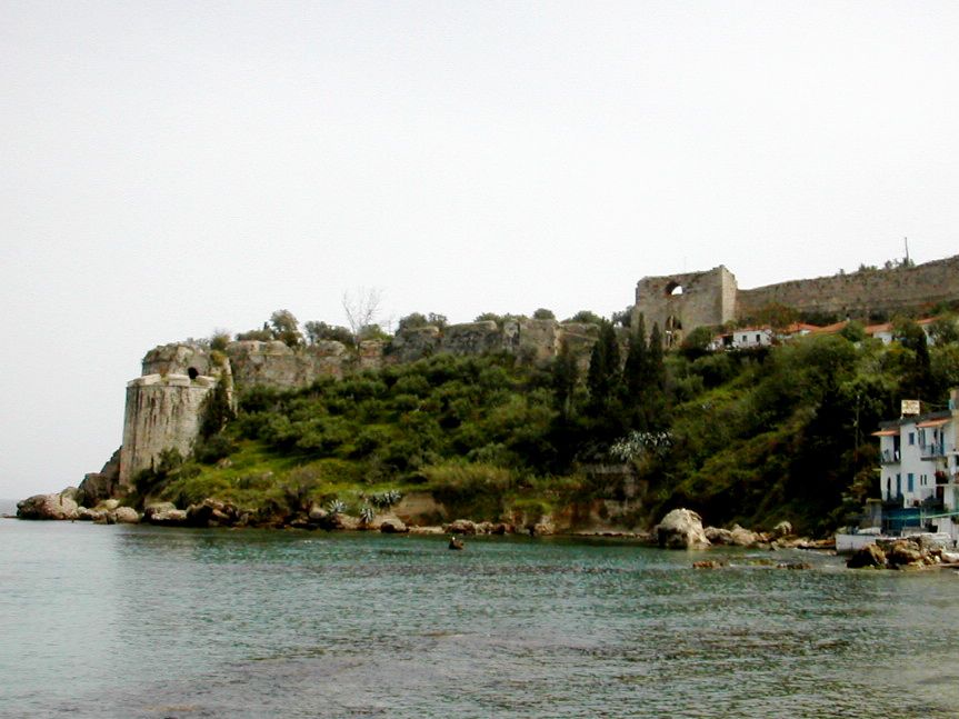
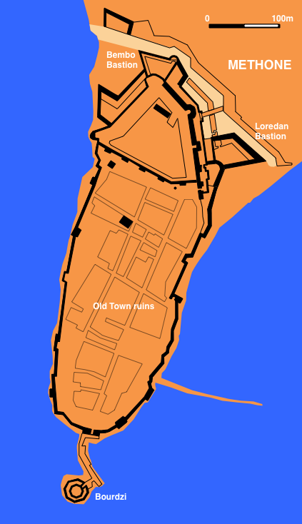
Methone
This
small flat peninsula with its natural harbour to the East has been
occupied and fortified from the earliest times. It featured in the
Peloponnesian wars of the 4th century BCE, was taken by the Macedonians
and Romans and was later an important port and fortress for the
Byzantines. Following the collapse of the Byzantine empire after the
fourth crusade the town was taken by the Franks in 1205 then occupied
by the Venetians the following year. They maintained it as a trading
port until 1500 when it fell to the Turks. The Knights Hospitallers
failed to recapture it in 1531 and it remained in Ottoman hands until a
three week siege in 1686 began the second period of Venetian
occupation, By 1715 the Turks were back in control and remained so
until the Greek War of Independence following which in 1828 it was
briefly base to a French contingent. Italian forces built pillboxes
around the site, now largely removed, and it was damaged by two
separate explosions during WW II.
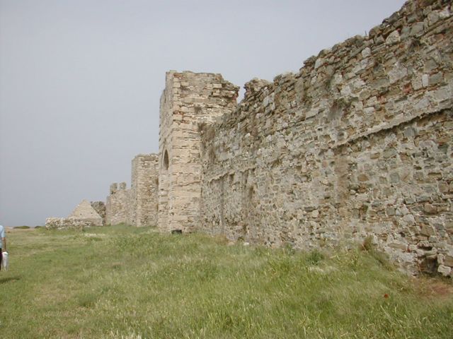
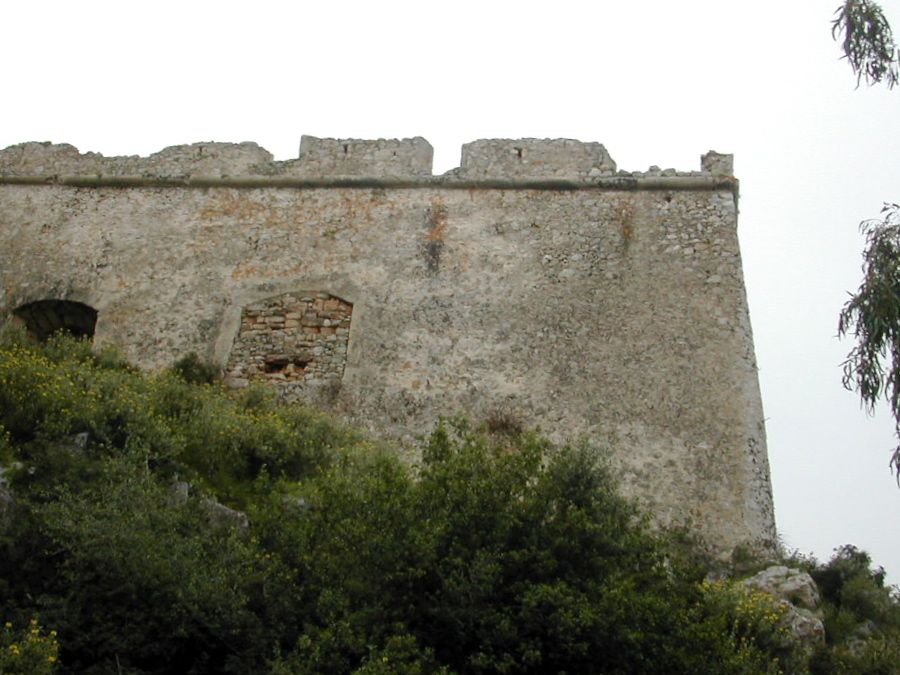
The
land front on the Northern side of the old town is the most strongly
defended sector. A broad ditch separates the peninsula from the
mainland. This was designed to be flooded by the sea but after several
remodellings remained unfinished. To prevent access to the north end of
the ditch a detached battery was built in the early 18th century . A
fausse braye defends the ditch between flanks of two bastions: Loredan
to the East and Bembo to the west.
The
Bembo Bastion from SE
Bridge and main gate from N
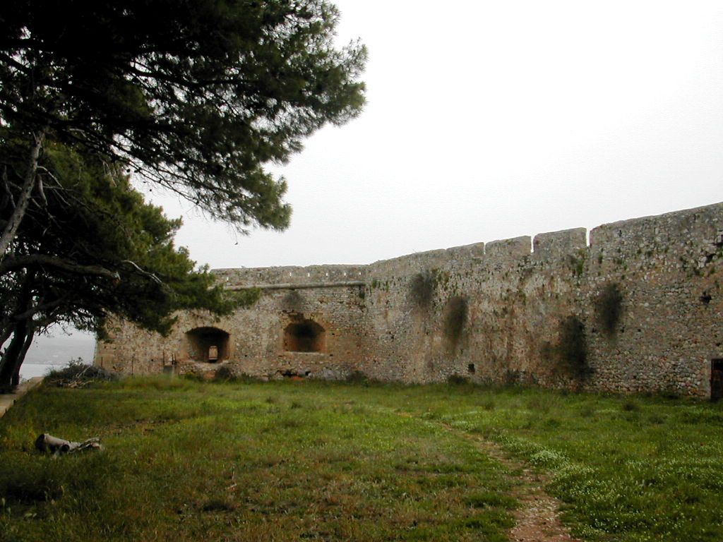
The
two bastions are linked by a double curtain wall which creates a
covered way between them. The inner wall may contain elements of the
original Byzantine defences although it is mainly from the first period
of Venetian occupation. In the 15th century it was strengthened with a
central round tower and the wall was reinforced by a hefty earth
rampart and a curved bulwark built at the east end. Late in the century
the fan shaped Bembo Bastion was added at the west end. Early 18th.
century improvements saw the Loredan Bastion built in front of the
eastern bulwark and the covered way extended to the east of the Bembo
Bastion to create a demi-bastion at a lower level. An additional
flanking battery in the shape of a demi-bastion was added to the
south.
The
entrance to the site is across a stone bridge built by the French in
the 19th. century to replace the earlier wooden one. The present outer
gateway is a fine example of early 18th. century Venetian work and is
decorated with carved flags and pikes. At the eastern end of the
covered way is a late medieval double gate giving access to the main
part of the town although the northern section immediately behind the
land front is closed off by a wall with square towers and a single gate
all dating from the 16th. century Turkish occupation.
Inner
Fortress Wall looking NW
The Sea Gate from S
The
wall around the remainder of the town follows the coast line and is
mainly 13th. century with considerable patching and other additions from
the following centuries. East of the Sea Gate is a square tower of the
16th. century ruined by a World War II explosion!
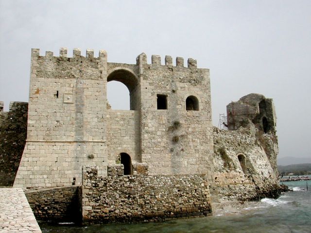
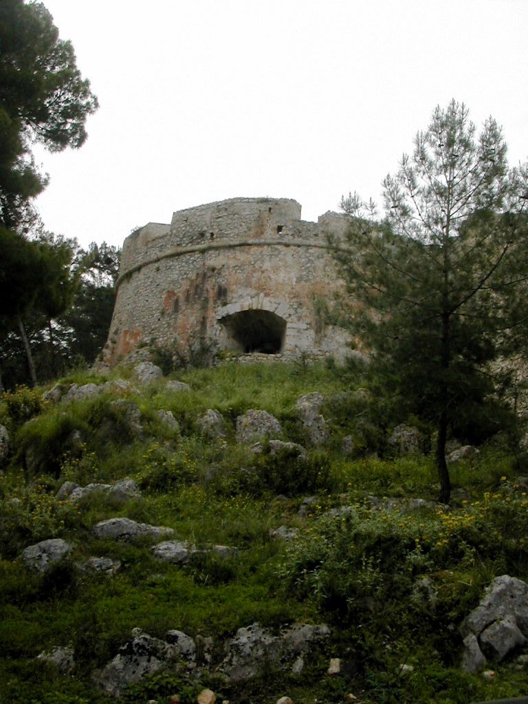
At
the southern tip of the peninsula is the Sea Gate with two square
towers, the eastern tower has some earlier Venetian material but the
entrance was remodelled in the 16th century with addition of the
western tower. A causeway links the gate to the small island fortress,
the Bourdzi. This octagonal lantern shaped tower of the 16th. century
has two levels within an outer wall with a loop holed parapet. Another
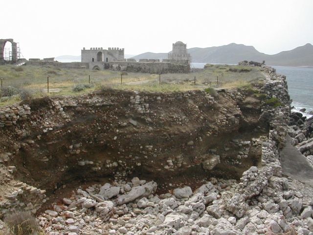
World War II explosion took out a section of the western curtain wall
revealing
the huge depth of stratified archaeological deposits which has built up
on the site.
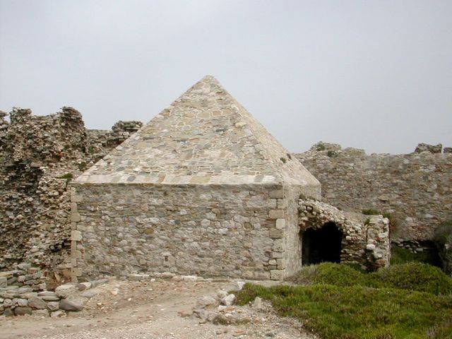
Other
surviving buildings include two 18th. century powder magazines, one with
pyramidical roof, a ruined Turkish Bath and a 19th. century chapel. Some
clearance has been done opening out the lines of streets and lanes from
the town which was finally abandoned early in the 19th. century
Magazine
from S
Stratification N
side of peninsula
looking S
Visiting
Methone
Public
transport options for getting to Methone are limited. There is a bus
service from Kalamata but for those who drive there is a free car park
on the site of the former glacis. The ticket office is sited on the
landward side of the bridge but when not staffed the gates appear to be
left open. Since the 1970s there have been sporadic campaigns by the
Greek Ministry of Culture to consolidate and restore the remains
despite this the area remains fairly unkempt and the walls in places in
poor condition. There is plenty of accommodation and several good
tavernas in town including the Methoni Beach Hotel (good for a cold
beer and fresh orange juice) and the Akro Giali restaurant which
lie on the beach next to the Loredan Bastion. There was no
guidebook to be had on site but the widely available publication “Pylos
– Pyla – A Journey Through Space and Time” has very good coverage of
all the fortifications in the vicinity.

Bibliography:
Castles of the Morea by Kevin
Andrews, Revised Edition, Princetown 2006
Venetians and Kinghts
Hospitallers – Military Architecture Networks, by Archi-med
Pilot Action, Athens 2002
Pylos – Pyla – A Journey
Through Space and Time by G. and T. Papthanassopoulos, Athens 2002
Fortresses and Castles of
Greece, Volume 2 by A. Paradissis, Athens 1994
Crusader castles in Cyprus,
Greece and the Aegean 1191 – 1571 by David Nicolle, Osprey Publishing,
London 2007
Venetian
Fortresses in Greece at: http://romeartlover.tripod.com/Venezia.html
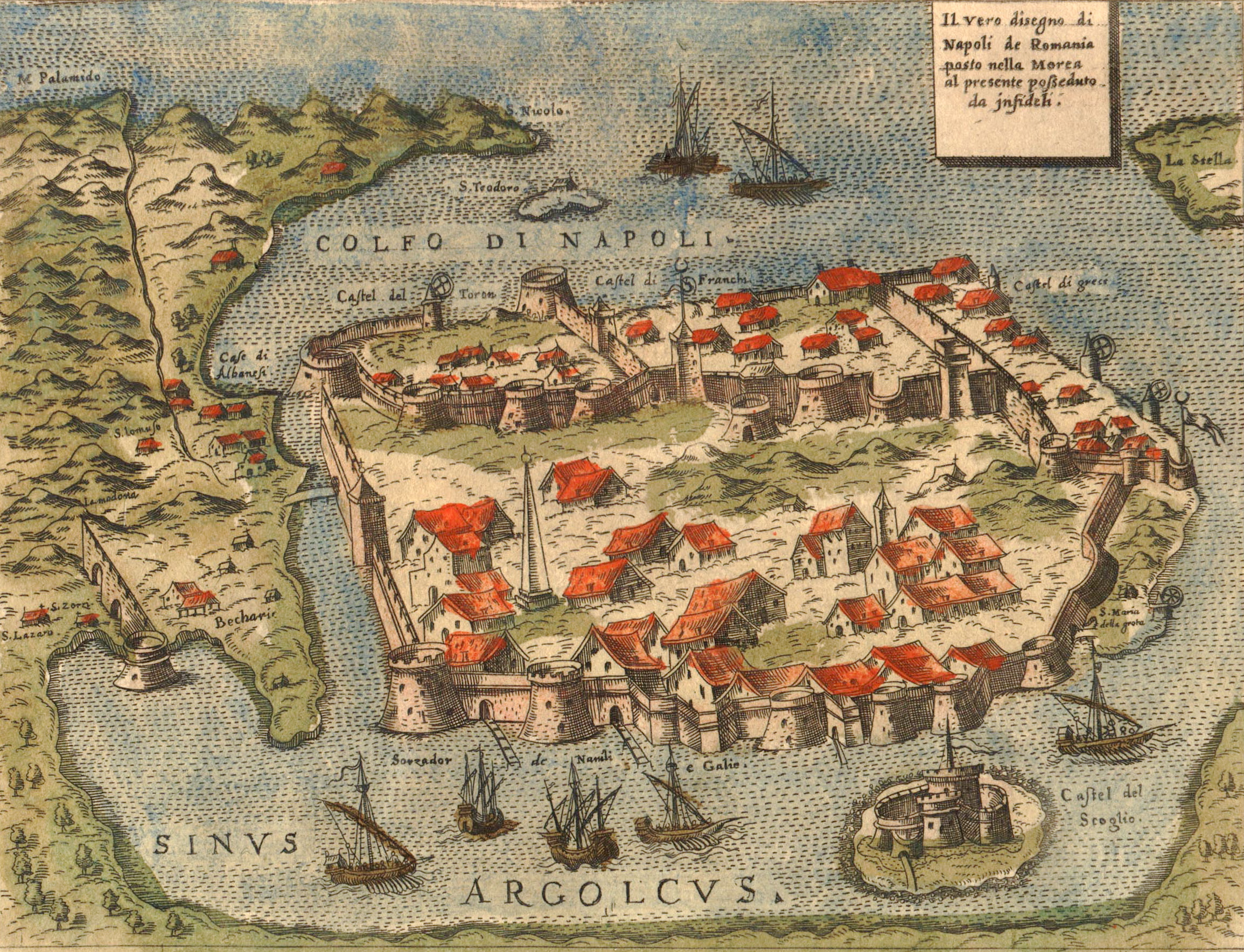
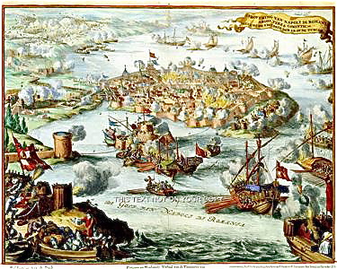
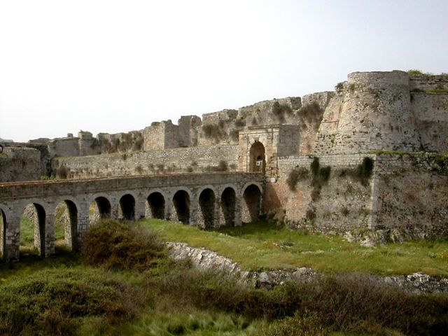
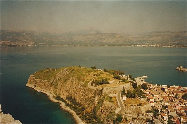
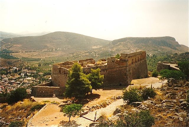
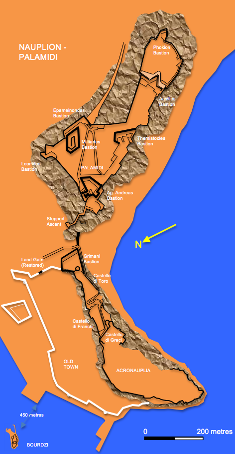
Nauplion – Palamidi
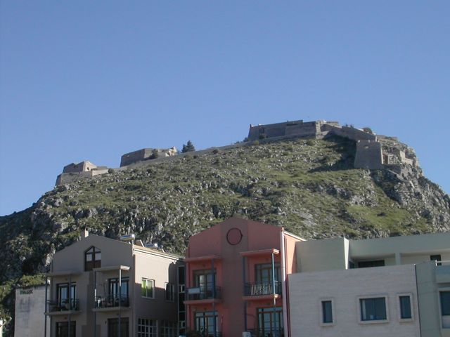
The
complex of fortifications centred round the town of Nauplion (or
Nafplion) is one of the most important and spectacular on the
Greek mainland. Defensive works from many eras are easily accessible
with the shady streets of the town offering respite and refreshment
between periods of ruin hopping.
The
modern town stands on largely reclaimed ground below a rocky promontory
that juts out into the Argolic Gulf. According to myth the town’s
founder was Nauplios, son of Poseidon. His son, Palamedes, after whom
the crag that dominates the town was named, was a participant
in
the Trojan War and was credited with the invention of writing. Whatever
the town’s early origins it was clearly an important port from the
outset and there are traces of a Mycenaean defensive wall near the S
corner of the Castello di Toro. The developing town was destroyed in
600 BCE by Argos because of its links with Sparta but by the
Hellenistic period it was sufficiently recovered to boast a fortified
acropolis. At a number of locations the roughly coursed rubble walls of
the medieval period are underpinned by the massive dressed ashlar
blocks from the classical walls.
Arab
incursions in the late 6th. century may have prompted a refortification
of Acronauplia by the Byzantines. Further work was probably undertaken
in the 11th. century, especially after Nicephoros Karentinos was
appointed ‘general’ of the town following a decisive defeat for Arab
forces in 1032. It is likely that a wall was extended to cover the
growing town at the foot of the acropolis in the 12th. century. After
the fall of Constantinople in 1204 and a successful two year siege by
the Frank, Godfrey de Villehardouin in 1210 the works of Acronauplia
were divided into two sections, the western most being left in the hands
of the Greeks – Castello di Greci, while the invaders occupied the
eastern portion – Castello di Franchi. In 1382 following difficulties
over inheritance the rights to the town were ceded to the Venetians who
took control for the next century and a half.
The
Venetians improved the layout of the town, erected a number of public
buildings and strengthened and updated the defences of both Acronauplia
and the town. They repaired the walls of the two earlier castles and
added the Castello di Toro to cover the approach from the
east.
They also erected in 1471 the small defensive work on an islet in the
harbour known as the Bourdzi. By 1530 the population stood at around
10,000. However, after fending off a number of Turkish raids the town
finally fell to Kasim-Pasha, vizier to Sultan Suleiman I, in 1540 after
a three year siege. The town was forced to capitulate having been
largely reduced to rubble by cannon mounted on the nearby Palamidi Hill
that overlooks the town.
1573
1686
17th. century
Following
the fall of Crete to the Ottomans the Venetian general
Francesco
Morosini attacked the town in 1686. The destruction of a powder
magazine close to the Land Gate together with much of the south east
quarter of town lead to the surrender of the Turkish forces. It had
become clear that the existing fortifications fell far short of what
was required for modern warfare. As well as reinforcing the entry to
the Acronauplia and covering the Land Gate with the massive Grimani
Bastion and strengthening the remaining walls and towers they also
began work to turn the towering crag of Palamidi into an utterly modern
and impregnable fortress. Its design was the responsibility of two
engineers: a Frenchman, La Salle and a Dalmatian, Giaxich, and it was
largely completed between 1711 and 1714, a remarkably short period for
such a massive undertaking. However, in 1714 when the Ottoman general
Ali Dagut Pasha attacked with an army of over 100,000 there were only
1,700 defenders to oppose him and the Palamidi fell after a siege of
just two weeks allegedly because of the treachery of its French
commander.
1700
During
the second period of Turkish occupation the town became something of a
provincial backwater and little was done with its defences except an
extension eastward to the Palamidid and some limited maintenance work.
At the outbreak of the Greek War of Independence in 1821 a series of
attacks and a protracted siege lead to the fall of the town and its
defensive works in November 1822. From 1828 to 1834 Nauplion
was
the first capital of the new Greek state.
Visiting Nauplion – Palamidi
Acronauplia
The
headland can be approached on foot from the town. Any one of a number
of lanes approach the foot of the acropolis rock at which point one
turns left and follows a path that leads through a gate flanked by a
round tower into a open space in front of the east facing wall of the
Castello di Franchi. Try and ignore the decaying concrete and glass
former Xenia Hotel that takes up most of the internal space of the
Castello di Toro.
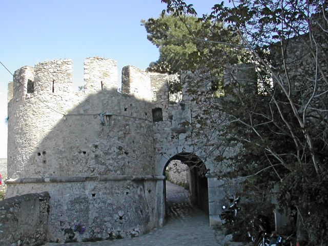
Gate
to Castello Di Toro from W
N wall of Acronauplio looking E
E Wall of
Castello Di Greci
A
road curls
round the southern end of
this wall
revealing the ruins of a number of chambers built against the inside
face. Further up the slope is the massive cross wall which marks the
eastern limit of the Castello di Greci, reinforced by the Venetians
with a talus and a low round tower loopholed for musket fire. The hill
top beyond this is an overgrown and rather confusing jumble of low
ruined walls and impenetrable scrub. Retracing one’s steps and
following the road past the derelict hotel leads to a large circular
artillery tower of the late 14th. century which marked the eastern end
of the Castello di Toro. Beyond this is the huge quadrangular Grimani
Bastion of 1706. This replaced an earlier detached ravelin and was
contiguous with the east front of the town wall. The bastion was banked
inside into three terraces backing onto the parapet with embrasures.
Below these are a series of vaulted galleries. Part of the walling
consists of large rusticated blocks of stone which are carried up the
angle of the bastion to the height of the cordon. In a park below the
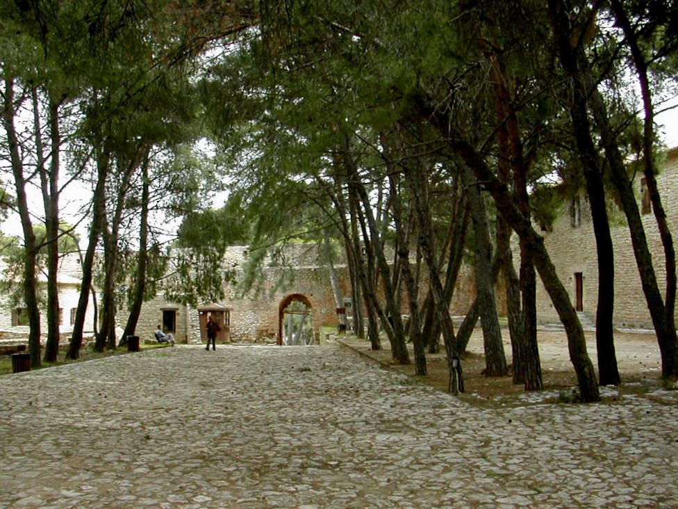
bastion are the reconstructed remains of the Land Gate and a section of
town wall and moat.
Grimani
Bastion
Acronauplio from E
Restored Land Gate with Grimani Bastion and 14C artillery tower
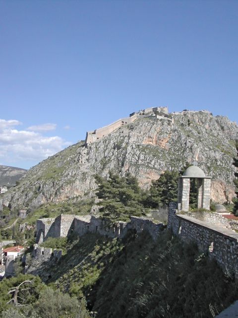
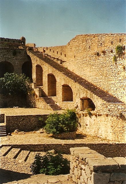
Steps on W face of Palamidi
and Caponier
Vehicle
access is available from the town but many visitors prefer to
experience the extraordinary climb up the staircase which zig-zags up
the northern face of the crag. This can be quite challenging as for
much of the day the 900 or so steps rising around 200 metres are in
full sun. However the ascent does offer a magnificent unfolding
panorama of the old town and Acronaupila and a view of the curious
loopholed caponier like structure which runs down the lower portion of
the slope. Half way up one passes the small Robert Bastion
before
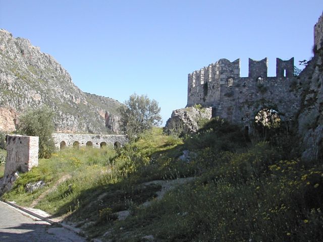
entering through a series of gates and terraces the massive Ag. Andreas
Bastion. This was the first to be completed in 1712 and illustrates
well the concept behind the fortress which is that of a series of
detached and semi-independent forts located within a larger but less
heavily defended outer enclosure wall. The bastion was fitted
out
as the command point for the garrison and as well as residential
accommodation included a small church dedicated to St. Andrew. The
walls can be approached either by steps or a horribly slippy steep
stone ramp now highly polished by the feet of passing tour groups.
The
Robert Bastion
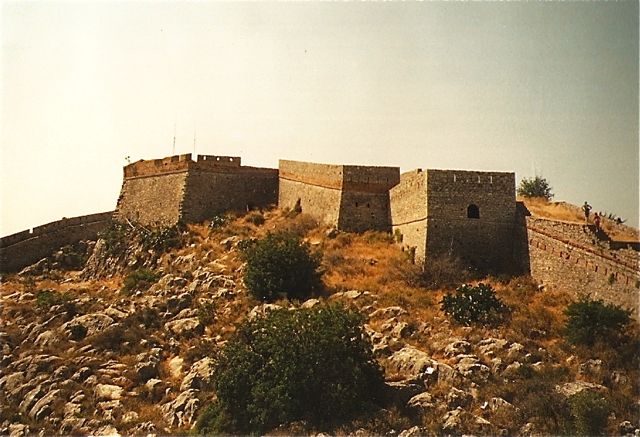
The
Ay. Andreas Bastion from
E
The
Ay. Andreas Bastion Interior
To
the north is the small Leonidas Bastion defending the northern most
corner of the enciente and beyond this looms the huge bulk of the
Miltiades Bastion, really a detached pentagonal fort in the form of an
acute angled ravelin pointing towards the main land approach from the
east. It contains a large rainwater cistern and a number of dismal
chambers which functioned as prison cells from 1840 until 1920. Further
east against the cliff top is the Themistocles Bastion
containing
a six gun battery which would also flank the approach road from the
east and dominate a ridge which extended along the cliff top further to
the east. The Achilles Bastion occupies the central portion of this
ridge but was possibly unfinished at the time of the Turkish assault as
it was here that the breakthrough was made. Beyond it is the Phokion
Bastion built by the Turks after 1714 to strengthen what they obviously
saw as a weakness in the defences.
The
Miltiades Bastion from W
The Themistocles Bastion from N
An
admission charge is made and the whole site is freely accessible
although there is little by way of facilities within the
fortress
except for a couple of water taps.
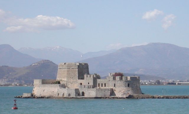
The Bourdzi
The
Bourdzi.
This
well preserved little fort has fulfilled a number of non-defensive
functions including being the home for the town’s executioner. More
recently it has been a hotel, a restaurant and a cultural centre. There
are many small boats available with boatmen to take visitors round the
island but it is best to check with the tourist information office
opposite the bus station for current arrangements for access.
Bibliography:
Castles of the Morea by Kevin
Andrews, Revised Edition, Princetown 2006
Venetians and Kinghts
Hospitallers – Military Architecture Networks, by Archi-med
Pilot Action, Athens 2002
Fortresses and Castles of
Greece, Volume 2 by A. Paradissis, Athens 1994
Nauplion-Palamidi by E.
Spathari, Hesperus Editions, Athens 2000
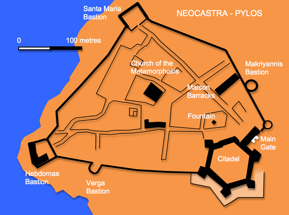
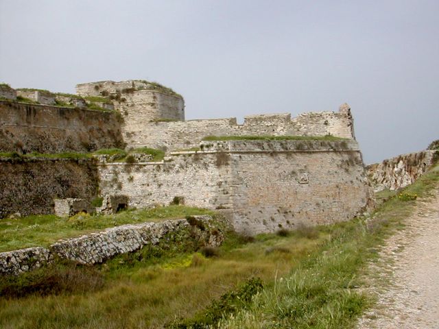
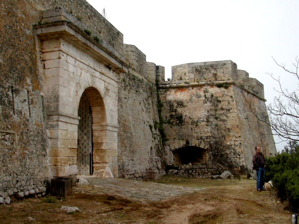
Pylos – Neocastro
The
Bay of Navarino on the west coast of the Peloponnese has a long
military history stretching back to the construction around 1300 BCE of
the Mycenaean citadel known today as ‘Nestor’s Palace’ some 8
kilometres to the north. In 425BCE at the battle of
Sphakteria
the Athenians defeated the Spartans below the classical city
of
Koryphasion which in its turn became a Byzantine
citadel
and a castle constructed after 1278 by the Franks and strengthened by
the Venetians and Turks, now known as the Paleocastro.
N gate, paved way and Maison
Barracks
In
1573, two years after the naval battle of Lepanto the Turks further
strengthened the defences of this important anchorage with a new work
opposite the southern entrance to the bay.
This
consisted of two large rectangular batteries dominating the entrance to
the harbour which may be earlier than the hexagonal bastioned citadel
on the crest of the hill. Between these was laid out a small walled
town with a central mosque. In 1686 the fortification was taken by the
Venetians under Francesco Morosini after a 12 day siege. During the
course of this operation and powder magazine exploded destroying the
northern most bastion of the citadel. The Venetians were quite
dismissive of the site’s military value citing its poor position and
lack of ditch. Ambitious proposals were drawn up for work including
three detached ravelins and a hornwork defending the approach to the
citadel from the east but apart from the construction of two curious
little loopholed ravelins in the ditch around the citadel little was
done. In 1715 after a lightening campaign by the grand vizier Ali
Kioumourtzi Turkish rule was restored and the Venetian forces driven
out. The declaration of war on the Ottoman Empire in 1770 by Russia saw
an attack on defences in the area by a small Russian force under the
brothers Orloff working together with local Greek forces. Neocastro
surrendered after a six day bombardment, however, following the arrival
of an Ottoman army consisting of several thousand Albanians the
Russians in turn withdrew. This failed uprising had tragic consequences
some of which were replayed in the Greek war of Independence
(1821 -1828). The Greeks captured the fortress after a siege lasting
several months and then held it until in 1825 Ottoman forces under
Ibrahim Pasha from Egypt landed and retook it. Intervention by the
three European powers of Britain, France and Russia saw the arrival in
1827 of a large combined fleet who anchored in the bay. Here they
clashed with a Turkish fleet whose almost total destruction signaled
the collapse of Turkish domination of the area. The castle was
surrendered to the French general Maison who carried out some repair
work and erected a new set of two storey barracks.
Venetian
Plan
and view early 18th century
Painting of 1825
seige
The
castle became a prison in 1864 and the interior of the citadel was
partitioned with radial wars to control the prisoners. During the
Second World war and number of gun emplacements were set up around the
castle. A major programme of restoration and rebuilding was carried out
between 1982 and 1987 opening part of the barracks as an art gallery
and setting aside other areas to serve the needs of the Greek
Centre for Underwater Archaeology.
Visiting Pylos – Neocastro
The
pleasant little town of Pylos can be accessed either bus from Kalamata
but for the independent traveler the best solution is to fly into
Athens and hire a car. This then also allows visits to be
made to
Koroni, Methoni and other sites in the area. The castle is open to the
public from Tuesdays to Sunday 8.30 a.m. to 3.00 p.m. with an entrance
charge of 2.50 Euros (2008).
Santa Maria
Bastion from N and S
Makriyannis Bastion from NW
Public
entrance is through a simple gate in the curtain north of the
Makriyannis Bastion. To the left is the restored Maison barracks and
the path leads to a crossroads in the centre of what would have been
the old town. To the right a path leads up the hill to the citadel past
a small rectangular fountain house. This was formerly fed by two
aqueducts which brought water to the town. The original main gate lay
to the north east of the citadel and consists of a heavily buttressed
square tower. The hexagonal citadel is now flanked by five (one having
been destroyed) small two story bastions. The citadel is entered
through a simple gate on its north face and a broad ramp gives access
to the wide paved wall walk which links all the bastions and the gate
tower.
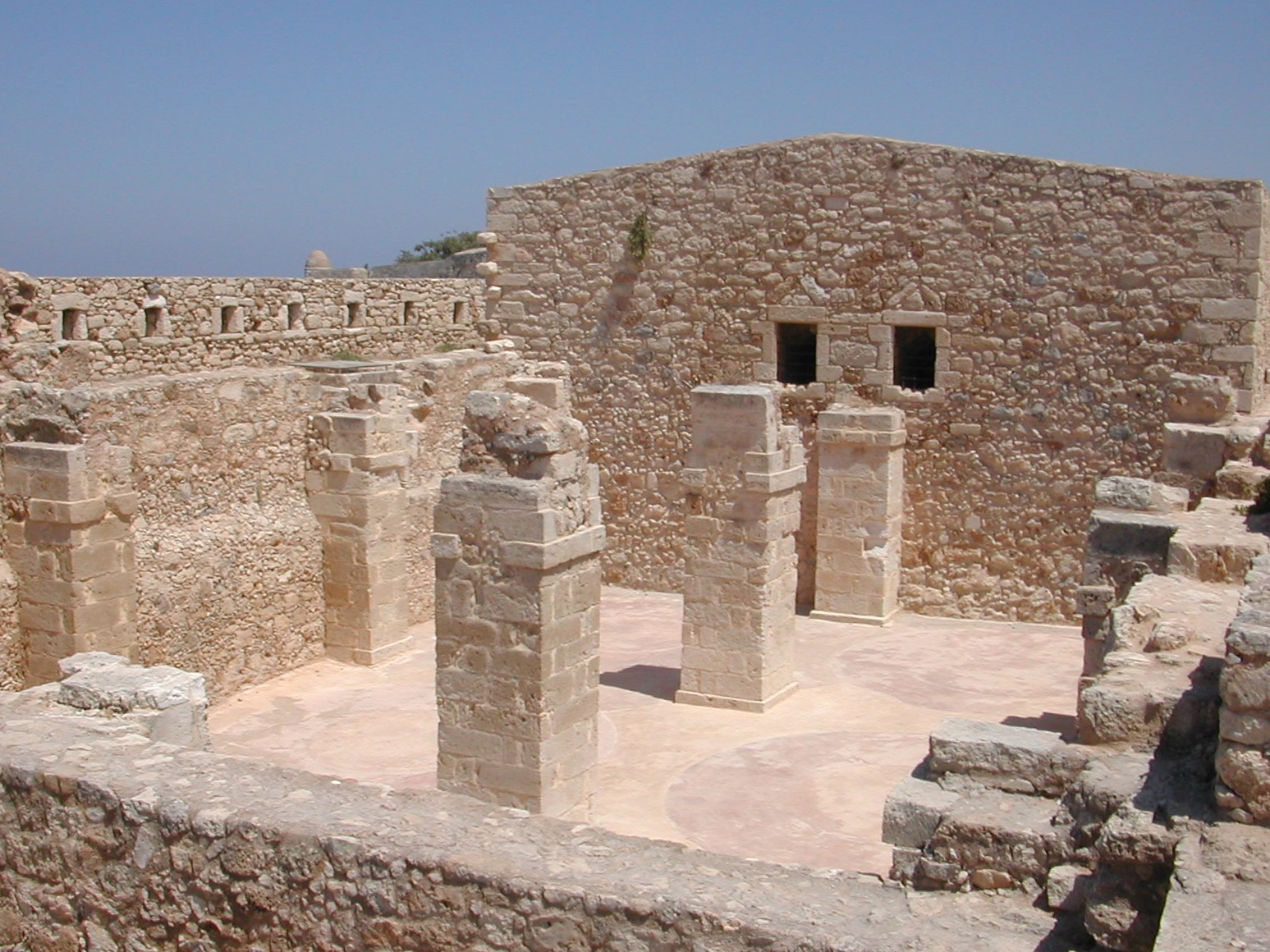
The Citadel: Entrance from N,
Ramp looking E, S Bastion from NE
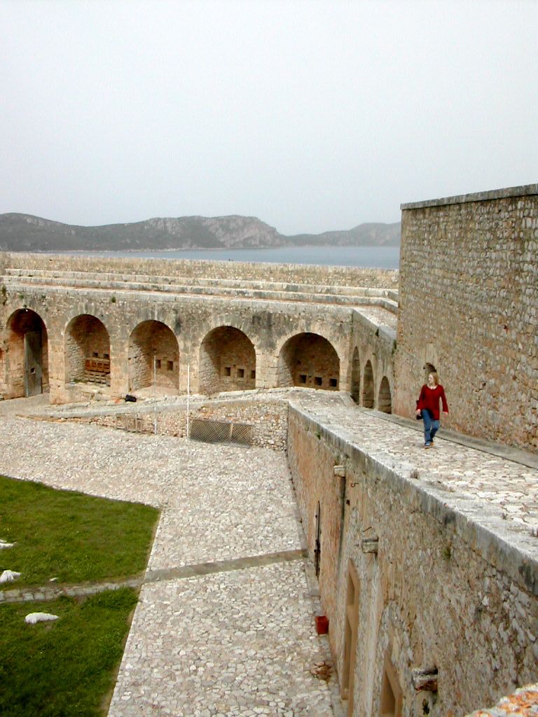
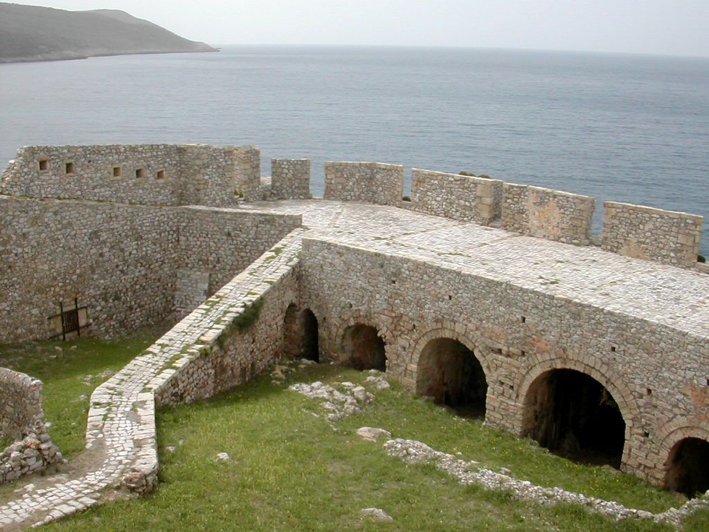
The
southern curtain carries an arcaded wall walk down to the semi-circular
Verga Bastion the interior of which was destroyed by British bombers in
1943 while the fortress was occupied by the Italians.
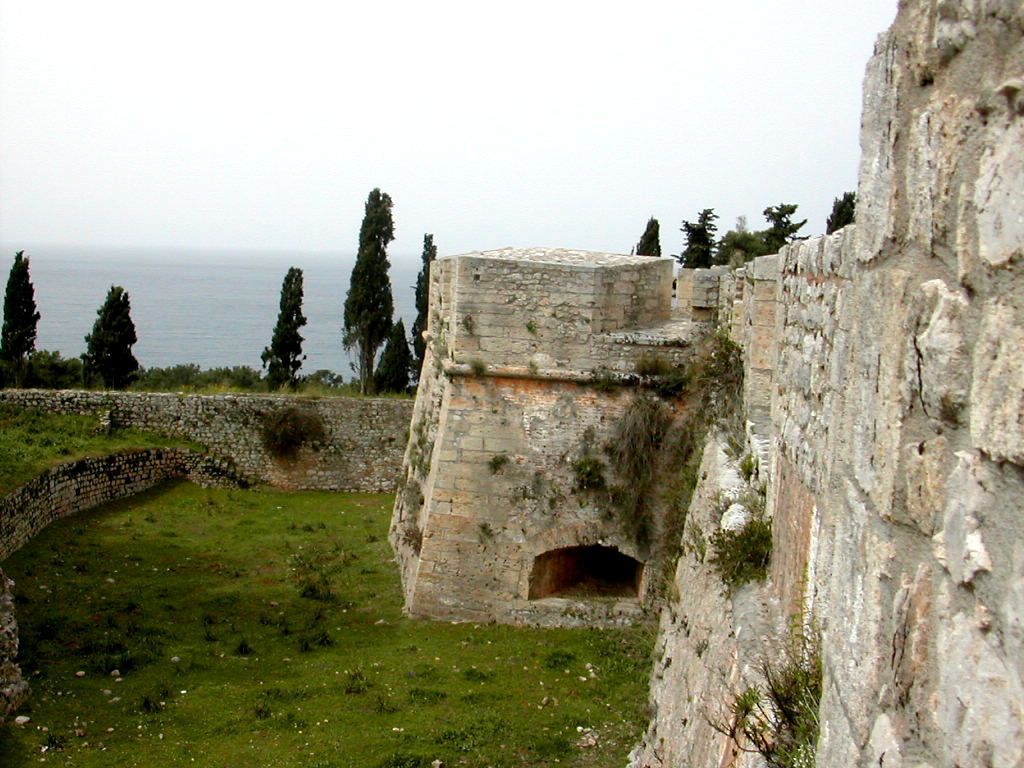
Overlooking
the rocky coast at the south west corner is the Hebdomas Bastion also
known by the Venetians as the Forte Santa Barbra. This carried 15
cannon placed at two levels. It was largely destroyed during the attack
of 1825 and rebuilt by the French. At the northern corner of the site
stands the second rectangular bastion known as the Santa Maria. The
interior contains a variety of overgrown foundations and ruins as well
as the aptly named Church of the Metamorphosis having been converted
either from mosque to church or vice versa no less than seven times.
Sadly it is currently closed having been badly damaged by fire.
The
Hebdomas Bastion, interior looking S
Church
of the Metamorphosis
from E
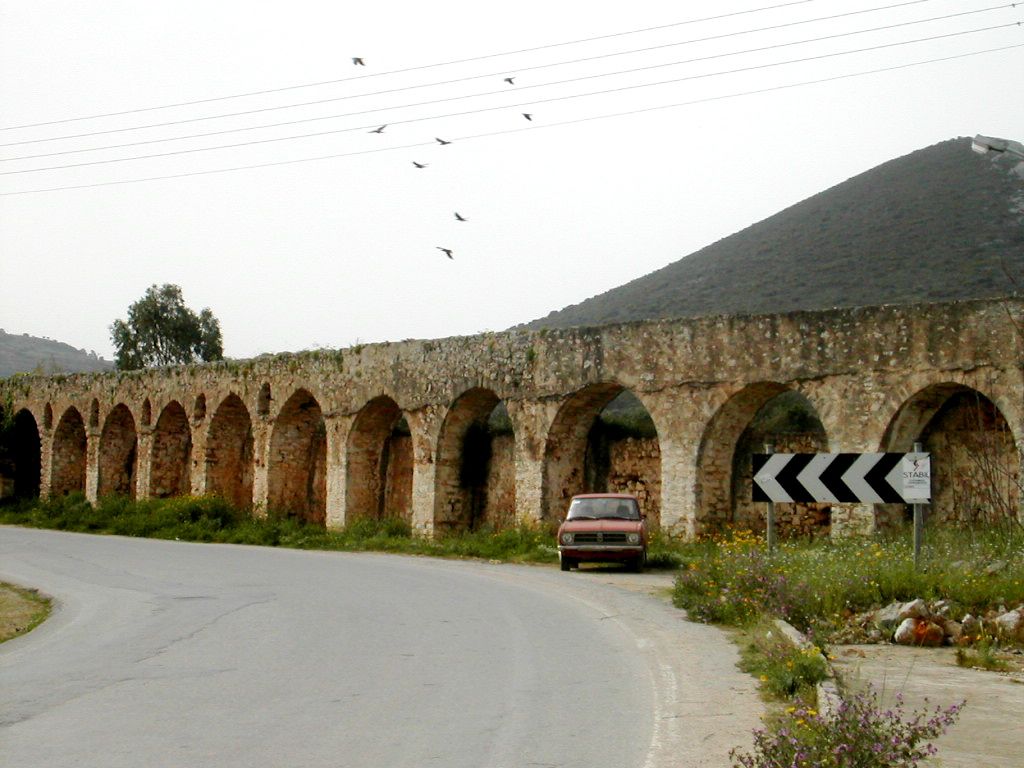
Aqueduct E of citadel
Bibliography:
Castles of the Morea by Kevin
Andrews, Revised Edition, Princetown 2006
Venetians and Kinghts
Hospitallers – Military Architecture Networks, by Archi-med
Pilot Action, Athens 2002
Pylos – Pyla – A Journey
Through Space and Time by G. and T. Papthanassopoulos, Athens 2002
Fortresses and Castles of
Greece, Volume 2 by A. Paradissis, Athens 1994
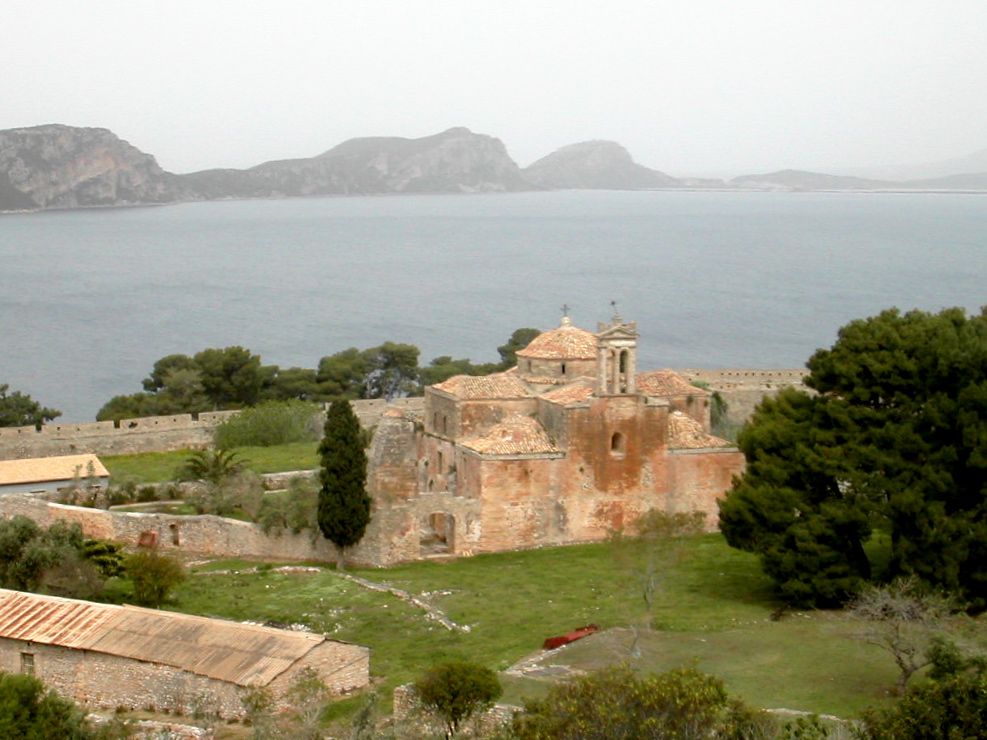
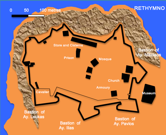
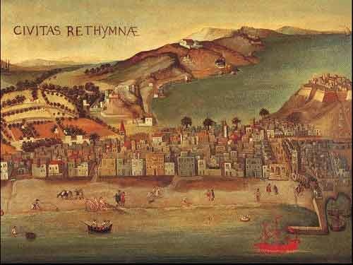
The Fortetza of
Rethymno - Crete
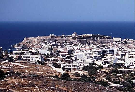
The
rocky coastal headland at Rethymno in northern Crete has been occupied
since prehistory. In classical times it is likely that the area was
site of an acropolis and temple to Artemis whilst the civil settlement
occupied the ground covered by the modern town. Little is known of the
town during the early Byzantine (325 – 824) and Arabic (824
-961)
periods. During the second Byzantine period (961 – 1204) a defensive
wall with round towers enclosing a roughly triangular area was built
next to the small harbour. This was taken over by the Venetians,
following the fall of Constantinople to Frankish and Venetian forces in
1204 but it was not until the disaster of 1571 when a Turkish raid
resulted in the destruction of a newly constructed city wall and the
Byzantine Fortress that thoughts turned to refortifying what was known
to the Venetians as the palaeo kastro or ‘old castle’.
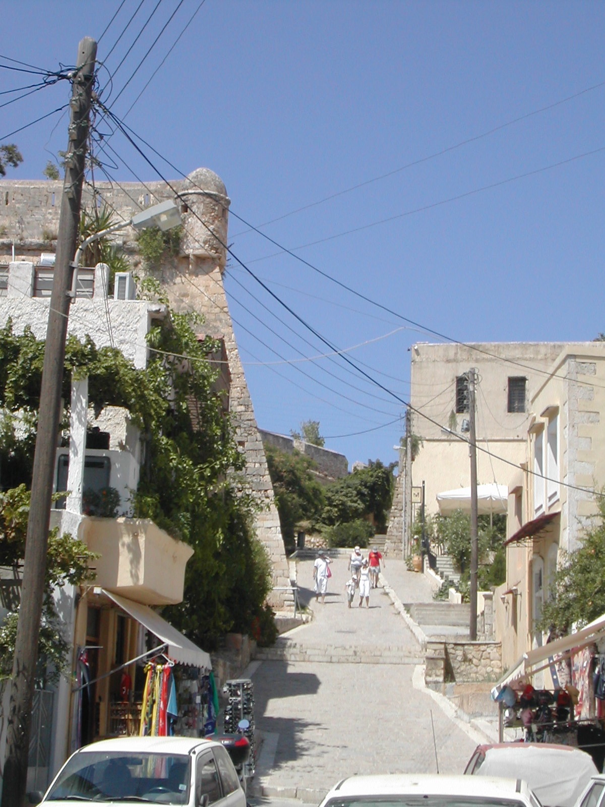
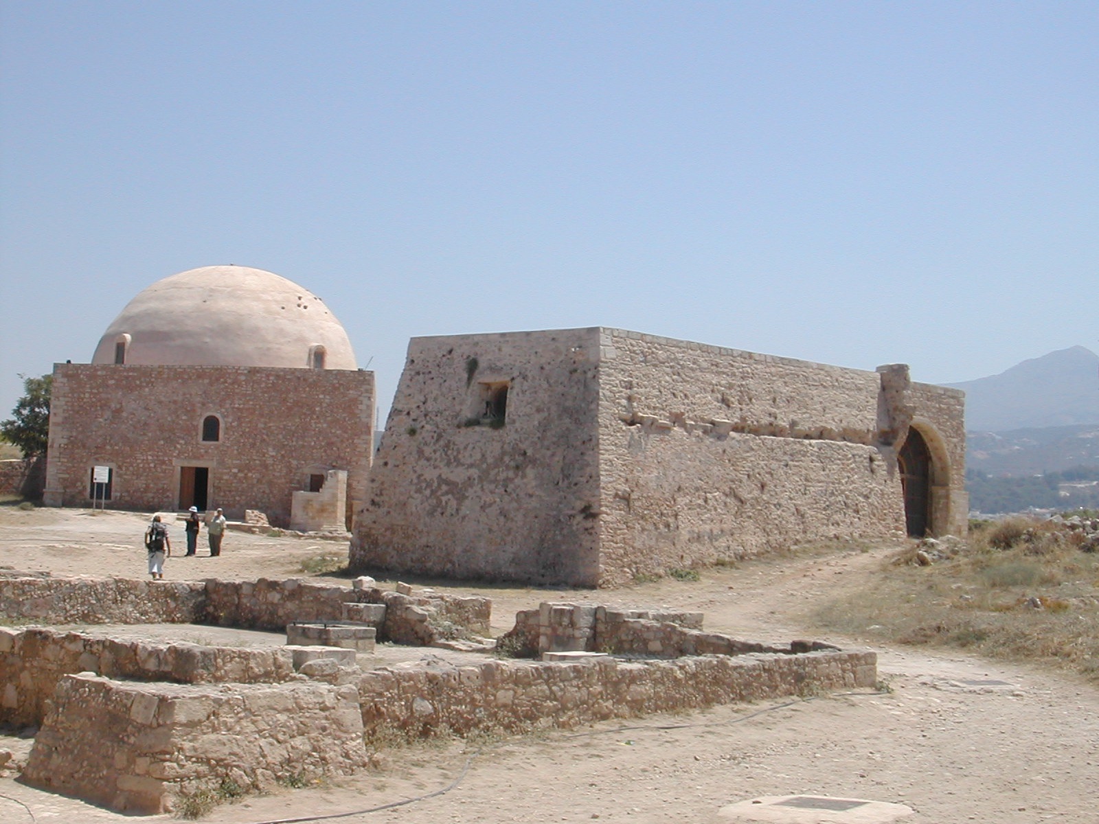
Approach
from S, ravelin on right
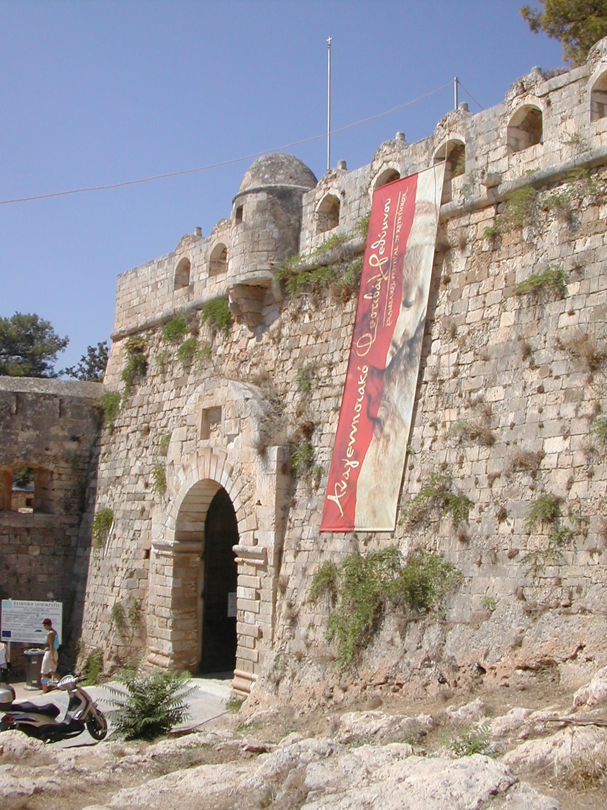
Main Gate from NE
In
1573 work began on this new larger fortification on the site of the old
acropolis which would, it was hoped, be large enough to rehouse the
whole population. Initial plans were drawn up by the architect Sforza
Pallavicini and realised by the engineer Gian Paolo Ferrari. The fact
that the trace of the new bastioned defence work had to follow the
profile of the hill top so closely meant that dissatisfaction was
frequently expressed by the Venetian military engineers about the short
comings of the new fortification, especially the narrow flanks to the
four bastions which protected the landward side.
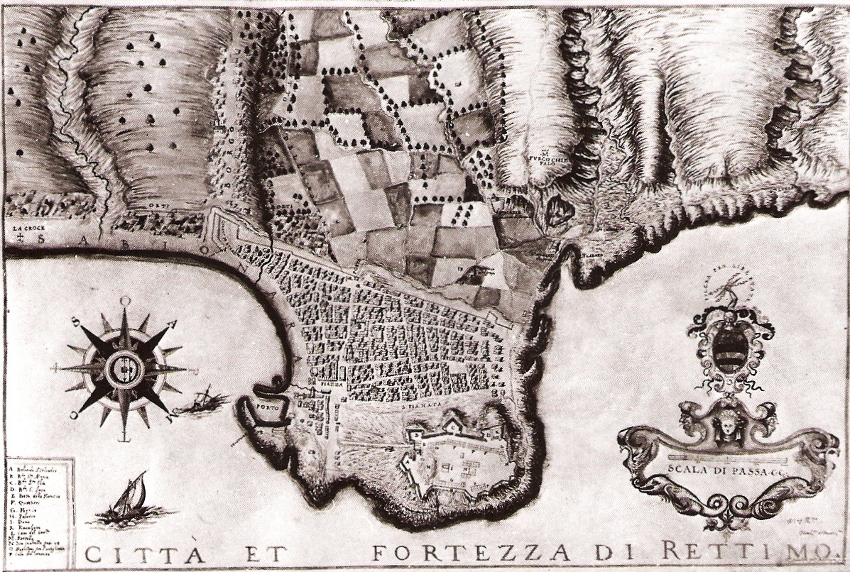
Plan
late 17th century
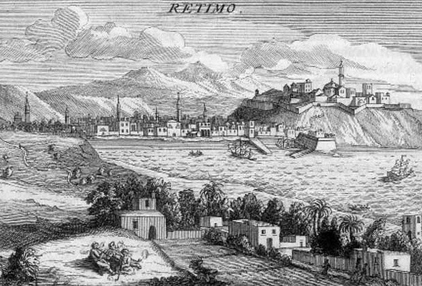
Engraving 1717
Cost
constraints and a number of changes in plan meant that only a portion
of the new fortress was occupied, largely with important civil,
ecclesiastical and military buildings. The bulk of the population
rebuilt their homes on the lower ground adjacent to the fortress on the
SE. A number of impressive structures exist in town dating from this
latter phase of Venetian constriction, most notably the Loggia
constructed around the middle of the 16th century possibly to the
design of the military architect, Michele Sanmicheli. It has
been
suggested that as well as functioning as a meeting place the strongly
built rectangular structure as served as a detached fort in times of
need. Other relevant remains of the fortified town are the Rimondi
fountain on 1626, the much decayed remains of barracks associated with
the Santa Barbara Bastion on the SW corner of the town defences and an
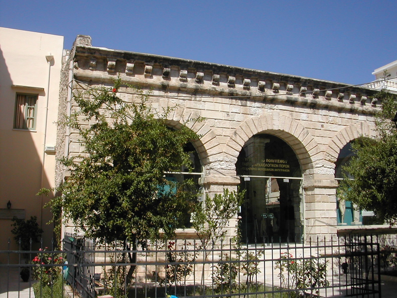
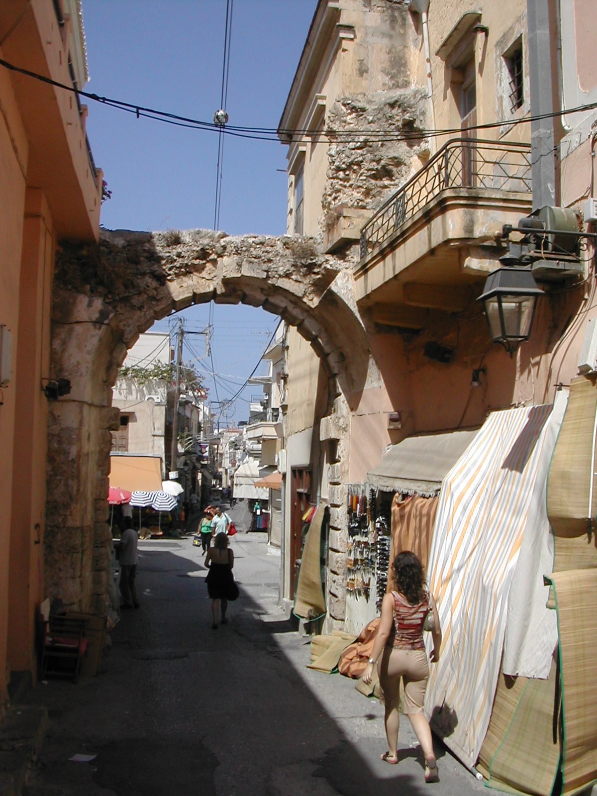
arch marking the site of the once important Porte Guora.
Barracks at St Barbara Bastion
The Loggia
Porte Guora
The
Venetian fortress was finally put to the test in 1646 when the whole
complex was captured by the Turks after an outbreak of plague amongst
the defenders.
The
Turkish authorities undertook basic maintenance on the walls and
erected a large detached raveling to cover the approach to the main
gate from the east. During the following centuries a range of domestic
buildings came to occupy the interior of the fort which much diminished
its military capabilities. Clearance, repair and restoration began
after the Second World War.
Magazine
Prison and Mosque
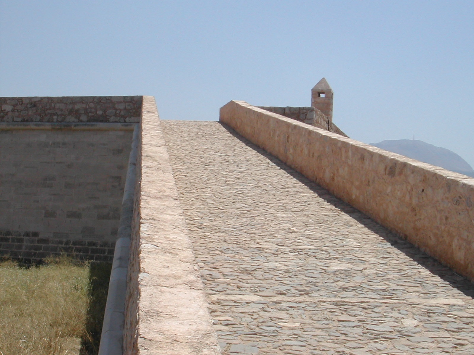
Ramp to
Ay. LoukasBbastion
Visiting
Rethymno.
The town remains one of the most attractive in Crete but
becomes very crowded in the main holiday season. A modern and
attractive archaeological museum now occupies the Turkish ravelin which
while very interesting in its own right rather obscures the internal
arrangements of the defensive work. Entrance to the fortetza
is
by the ticket office situated inside the main gate. Access to all parts
of the fortress is freely available and there is considerable
restoration work still underway. The most impressive work done to date
includes the clearance and consolidation of the main magazine close to
the north wall and the repairs to the ramp and cavalier that dominates
the Ay. Loukas Bastion. Another striking monument is the
Mosque
of Sultan Ibrahim on the site of the former Cathedral. A complete
circuit of the defences is possible offering striking views over the
town and coast.
The site is in the
guardianship of the Greek Ministry of Culture and a useful guidebook is
available.
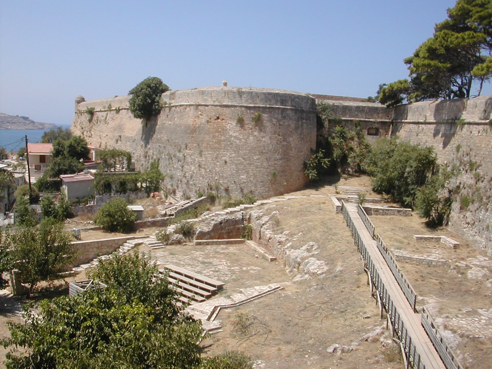
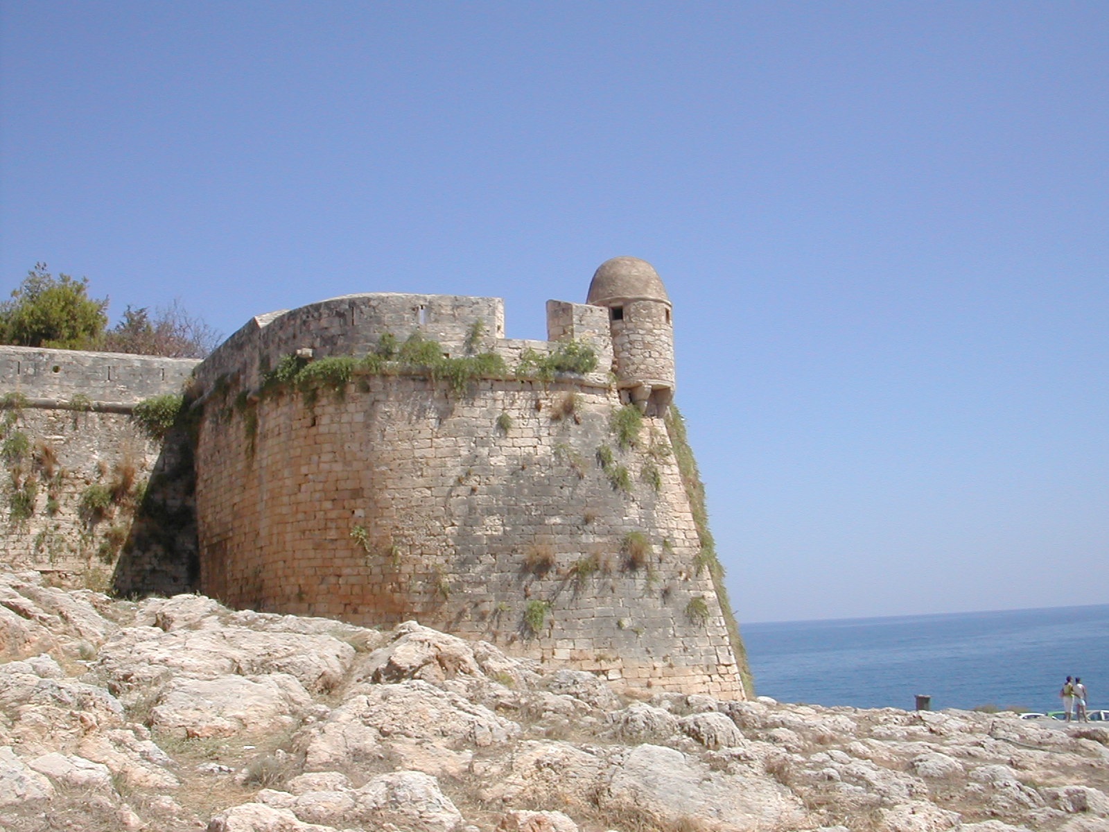
Bastion
of Ay. Loukas from E
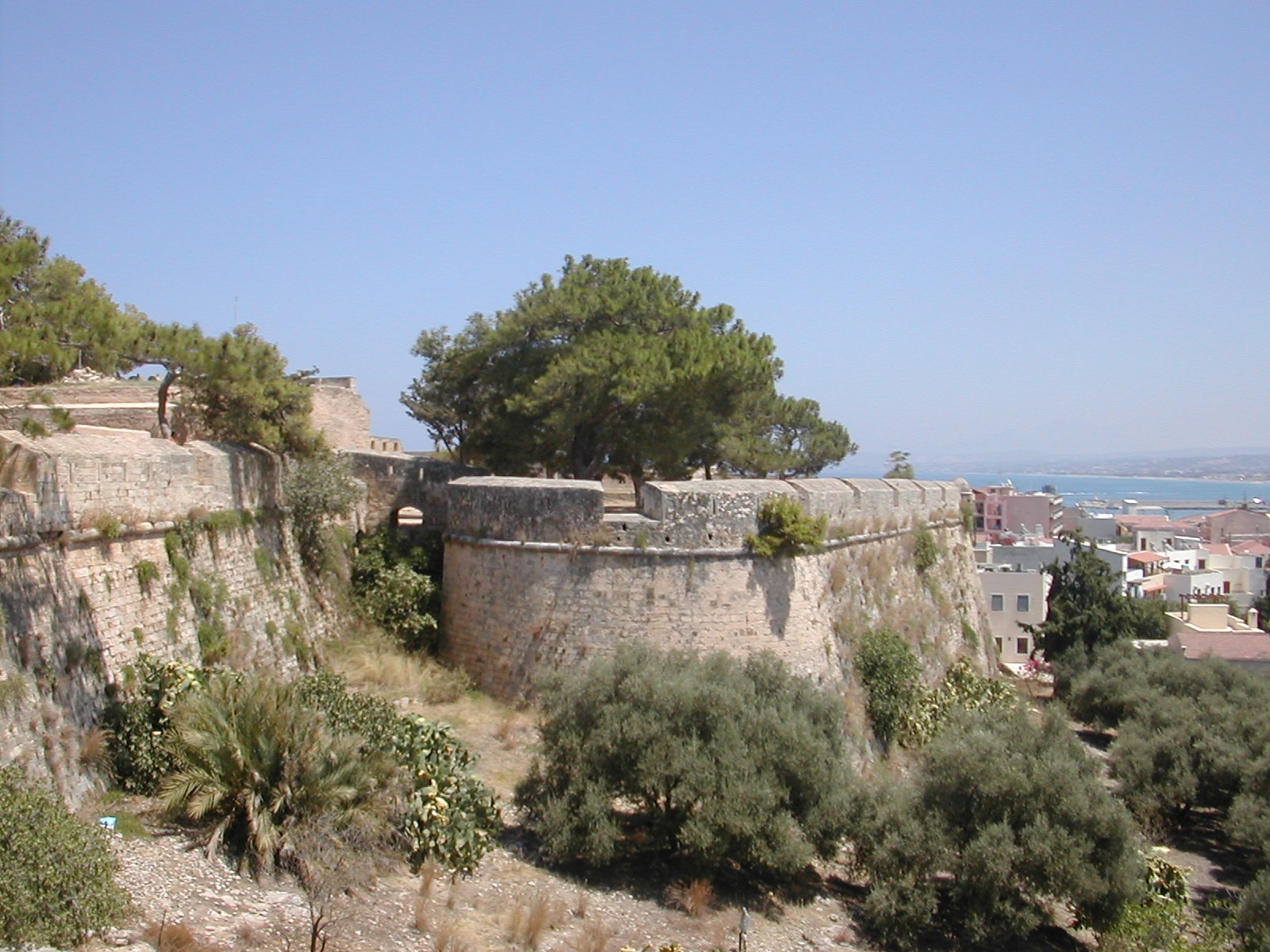
Bastion of Ay.
Pavlos from W
Bastion of Ay. Nikolaos from S
 17C view
Bibliography:
Castles of the Morea by Kevin
Andrews, Revised Edition, Princetown 2006
Venetians and Kinghts
Hospitallers – Military Architecture Networks, by Archi-med
Pilot Action, Athens 2002
Rethymno by S. Kaligeraki,
Mediterraneo Editions, Athens 2002
Fortresses and Castles of
Greece, Volume 3 by A. Paradissis, Athens 1999
The Fortetza of Rethymno by I.
Steriotou Athens 1997
Venetian
Fortresses in Greece at: http://romeartlover.tripod.com/Venezia.html