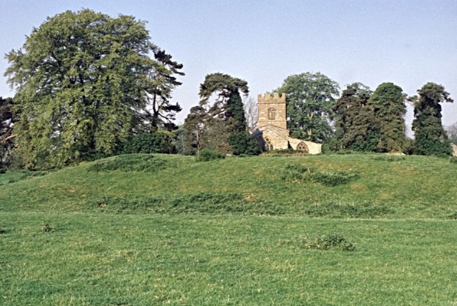
Fig. 1 Berry Close, view looking west showing the possible manor mound and the church of St Peter and St Paul.
1.0 INTRODUCTION
1.1 General background
1.1.1 This document comprises the written scheme of investigation (WSI) for archaeological investigation, monitoring and recording of the erection of a large stone monument close to the east entrance to Berry Close, commemorating the donation of the field to the community of Chacombe (Fig. 1).
1.1.2 Polyolbion Archaeology has been commissioned by the Friends of Berry Close on behalf of Chacombe Parish Council to prepare this scheme following the decision by Andrew Preston (Ref S/2013/0641/MAF), which imposed the following condition.
Prior to the placement of the commemorative stone the applicant or their agents or successors in title shall secure the implementation of a programme of archaeological work in accordance with a written scheme of investigation including a timetable which has been previously submitted to and approved in writing by the Local Planning Authority.
1.1.3 The site under consideration lies close to the eastern margin of the field just to the north of the current access to the field comprising of a wooden field gate and a wooden bridle gate (Fig. 2 and Fig. 4). From this point three public footpaths cross the field in different directions.
1.1.4 The development comprises the erection of a large ironstone monolith with a maximum height of 2.75 m (when erected the height exposed above ground will be approximately 1.85 m), maximum width 1.42 m and maximum depth of 0.6 m. It will be erected at the top of a low bank which flanks the entrance to the field (Fig. 3 and Fig. 4). Because of the size of the proposed monument there will need to be significant ground works to ensure its safe placement.
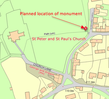
Fig.2 Berry Close, area for investigation
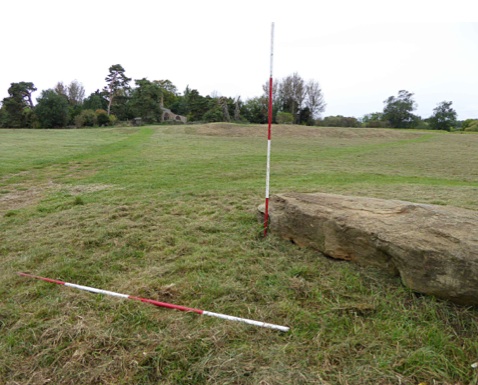
Fig. 3 Berry
Close showing the location of proposed monument, looking west from near
the entrance from Silver Street. The position and width of the
excavation is marked by the horizontal ranging rod and the
commemorative stone is lying to the right.
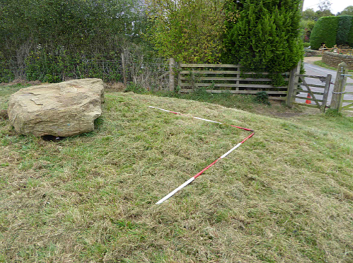
Fig. 4 Berry Close showing the location of proposed monument, looking east towards the entrance from Silver Street.
1.2 Site background
1.2.1 Topography. Berry Close is a significant parcel of land bequeathed to the residents of the Parish of Chacombe situated between some of the oldest buildings of Chacombe, with the 13th Century Church of St Peter and St Paul (Cameron B. D. 1996) at its western edge and at least one late medieval building in Silver Street to the east (Wood-Jones R. 1963). Prior to bequest it was a tenanted smallholding of sheep grazed pasture containing some small sheds, now demolished. The field contains a complex of earthworks, some well marked with others in a fragmentary state. The landscape is open and the topography consists of Chacombe brook flood plain at the northern end at 115 m OD, rising up to 120 m above OD at the southern end. On the south side it is bounded by Church Lane and on the south end of the east side by Silver Street. Berry Close is above both roads to a height of nearly 2 m in places and the ground retained by a dry stone wall of unknown date. Beneath the soil there is likely to be alluvial clay, especially in the valley bottom. The underlying rock belongs to the Lias group and is predominantly an iron-rich limestone containing some shelly bands, though there may also be some mudstone and siltstone (British Geological Survey of Great Britain http//www.bgs.ac.uk/geoindex).
1.2.2 History. The Manor of Chacombe is of early origin. Bardi, a Saxon lord, owned three mills (Domesday Book). Over the years the name has appeared as Chaucomb, Chaucombe, Cheekham, Chacomb and Chalcombe and prior to WWII both Chalcombe and Chacombe were regularly used. The Oxford Dictionary of English Place-Names lists early names for Chacombe as:
Cewcumbe – Doomsday Book; Chaucumba 1166; Chaucumbe 1195 – Pipe Rolls; Chacombe 12th. C. Northants Survey) ‘Ceawa’s Cumb or valley’. The Old English personal noun is found in Ceawan Llaew 947
In the Domesday Book, Godfrey is recorded as holding the Manor of Chacombe in the fee of the Bishop of Lincoln. The Lord of the Manor in 1109, in the reign of Henry I, was Sir Hugh de Anas who came over with William the Conqueror in 1066. His son, Sir Roger de Chacombe, adopted the local name in lieu of Anas. Sir Roger de Chacombe’s son, Hugh, was justiciary of Normandy in the second year of the reign of King John, in 1200. He had a wife Hodierna, a daughter Amabilia, and he lived at the Manor. In 1209, Hugh de Chacombe entered the Augustinian Priory as a religious, indicating that the Priory was built in the early thirteenth century and it appears that Chacombe Church was rebuilt soon afterwards. The Priory grounds are about 500 metres west of Berry Close. In 1257 the whole manor was seized for debt by Henry III but eventually possession was restored to the Lord of the Manor at that time, Sir Robert de Chacombe. Robert had no son but one daughter, another Amabilia. She married Gilbert de Segrave, and so, on the death of Robert, the Manor became the property of the de Segraves. In the sixth year of office of the Bishop Grotête in 1241, William de Collingham was elected Prior of Chacombe by licence of Gilbert de Segrave, the patron Adam de Appelby succeeded in 1279 and Robert Warden in 1299. Alexander de Kaysthorpe was Prior in 1302 and, on his death in 1326, the Canons having made an irregular election, the Bishop, with licence from the King, appointed Roger de Silby, on 19th. April.
Thomas de Saxton, the next Prior, resigned in 1339 and was succeeded by Henry de Keysworth. On St. Michael’s Day, 1346, the Prior and Convent received Benefits conferred upon them by John de Lyons, Lord of Warkworth, who granted to them and their successors a sum “to find two secular priests who in the Chapel of Warkworth shall perform services for the healthful state of the said nobleman so long as he lives”.
On the 20th. March 1371, Edmund de Thorp became Prior of Chacombe and he had been followed by Thomas de Brackley by 1412. John Gerneall was Prior of Chacombe in 1495 and Thomas Saunders was the last Prior (Beesley 1841: 85-86).
1.2.3 Archaeology. The site of the medieval manor has not been firmly established but is stated by the RCHM (1981) as being on the mound forming the most prominent earthwork in Berry Close and at the highest point in it, dominating the older part of Chacombe village. Despite being damaged, it still has a substantial scarp, up to 2 m high, inside a ditch on the west. The proximity of this mound to the Church suggests that it is the site of a high status building.
A magnetometry survey of the non-floodplain sections of Berry Close (Northamptonshire Archaeology 2013) showed that medieval or early post-medieval settlement remains extend across much of the area surveyed. The dense and overlapping nature of the remains indicates that occupation was prolonged and the site went through more than one phase of development. However, the area in which the stone monument is to be placed has no visible features in the magnetometry results. Indeed, recent use of this area suggests that it is disturbed ground, at least in the surface layer.
Air photography of Berry Close shows outlines of banks and terraces, along with later small-scale quarry or borrow pits (RCHME 1982, 26; Northamptonshire SMR 27/3, 27/3/1, MNN14763, 123191). A hollow-way and possible settlement tofts and crofts from the once more extensive medieval village are situated to the north and north-east (SMR 27/0/1, 27/0/26, MNN17831, 1231).
The nearby Priory site is associated with a number of fish ponds, and air photographs show at least one fish pond along Chacombe Brook only just past the section of this brook that forms the northern boundary of Berry Close. The earthworks in the valley bottom of Berry Close might be associated with the medieval water management organised by the Priory.
About a mile away from the site but within the Parish a rectangular enclosure and other marks suggest a prehistoric or Roman site, but on a separate site there may be a substantial Roman building associated with Castle Farm, which is a little nearer. A Bronze Age scraper and some flints were discovered by a village resident on Chacombe Lodge Farm which is more than a mile from the site (Northants HER, found by Bowes J. 1997).
2.0 OBJECTIVES
Specific objectives of the investigation are to:
2.1 identify any previously unrecorded archaeological features and deposits of interest;
2.2 record identified archaeological features and deposits to a level to enable their extent and significance to be identified;
2.3 undertake sufficient post-excavation analysis to confidently interpret archaeological features identified during field work;
2.4 undertake sufficient post-excavation analysis of artefacts and samples to support interpretations made of features identified;
2.5 report the results of the excavation and post-excavation analysis and place them within their local and regional context;
2.6 compile and deposit a site archive;
2.7 involve a variety of stakeholders from the local community and Chacombe school children in archaeological activities for educational purposes and stimulate interest in history, archaeology and the heritage of Chacombe.
3.0 METHODOLOGY
3.1 All appropriate permissions will be obtained from the landowner and agreement sought in writing as to the future deposition and ownership of the archive (finds and documents) with the Northamptonshire Archaeological Resource Centre. Advice will be given regarding likely costs for archive deposition both physical and digital. At the outset a HER event UID will be obtained.
3.2 As part of the project a measured survey of the earthworks in Berry Close will be undertaken to provide a context for the bank on which the monument is to be sited. This activity will provide a focus for community activity on a comparatively large scale.
3.3 The archaeological excavation will be carried out in accordance with Institute for Archaeologists guidelines Standards Guidance for Field Evaluation (1999 rev. 2009) and Standards & Guidance for Archaeological Excavation (1999 rev. 2009). In addition the excavation will be carried out in accordance with relevant English Heritage guidance for specialist sampling, assessment and analysis as appropriate.
3.4 Polyolbion Archaeology will be responsible for site establishment and identifying the location of the excavation in accordance with this written proposal. We will also be responsible for site security and fencing and for providing welfare facilities and tool storage during the project.
3.5 Polyolbion Archaeology shall be responsible for identifying any services (both buried and overhead) and for taking all necessary precautions to avoid damage to these services.
3.6 We recommend that an area of 2 metres by 1 metre and to a depth of 1 metre be examined as sufficient to accommodate the ground works as required by the contractor. Turf and topsoil will be stripped by hand using forks, spades and shovels in all cases. The turf and topsoil will be separated and stockpiled at a safe working distance from the trench sides in order to be available to re-instate the site once the stone has been installed. The top of the first significant archaeological horizon will be exposed as outlined above and will then be cleaned by hand as necessary and inspected for features. Further excavation will be undertaken down to a limit as advised by the contractor.
3.7 The lead archaeologist shall be responsible for liaising with the contractor in respect of all operations where an archaeological interest exists.
3.8 All artefacts will be retained for processing and analysis by appropriately qualified and competent authorities. Where it is considered potentially beneficial appropriate environmental samples will be collected and screened for analysis.
3.9 Significant waterlogged deposits are not anticipated, however should they be encountered additional sampling may be undertaken. Sampling will be undertaken in accordance with English Heritage guidelines Environmental Archaeology A guide to the theory and practice of methods, from sampling and recovery to post-excavation (2011).
3.10 If deemed appropriate for occupation layers such as floors of buildings; ditch, pit and posthole fills; and the fills of other cut features, bulk samples for coarse sieving and flotation will be taken. Sample sizes will be a minimum of 40 litres or 100% of the sample of the feature excavated. Bulk samples may be sub-sampled at a later stage for particular analyses (e.g. molluscs). Samples suitable for scientific dating will be taken if encountered during the excavation. Advice will be sought from appropriate specialists as to the most appropriate sample methodology and will be undertaken in accordance with the relevant English Heritage guidance for the technique.
3.11 If human remains are encountered their excavation and lifting will only be undertaken under licence from the Ministry of Justice, complying with the requirements of the 1857 Burial Act and environmental health regulations. A Ministry for Justice license will need to be obtained prior to the removal of the remains and provision will be made for the specialist reports on the remains by a recognised osteoarchaeologist.
3.12 Artefacts classified as Treasure under the Treasure Act (1996) will reported in accordance with the requirements of the Act. Any finds will be removed to a safe place and be reported to the local coroner as required by the procedures as laid down in the Treasure Act Code of Practice 2002. Where removal cannot be effected on the same working day as the discovery, suitable security measures will be taken to protect the find(s) from theft.
3.13 The lead archaeologist will be undertaking his duties pro bono in order to support future community interest in the site and will recruit and train local volunteers to assist with the work.
4.0 CONTINGENCIES AND UNEXPECTEDLY SIGNIFICANT OR COMPLEX DISCOVERIES
4.1 Archaeological remains of a post-medieval and possibly medieval date are anticipated. Should unexpectedly extensive remains of previously unrecorded archaeology be uncovered the scope of this programme will be reviewed to determine the most appropriate recording and sampling strategy for the remains. Should there be unexpectedly significant or complex discoveries made that warrant a more detailed investigation than is appropriate within the terms of this proposal, then the scope of this work will be reviewed in conjunction with the client and the appropriate county archaeology officer.
5.0 RECORDING
5.1 All archaeological features and deposits encountered will be cleaned by hand and planned using an appropriate scale. The features will be investigated employing the sampling strategy outlined above and stratigraphic principles of excavation.
5.2 All excavated deposits will be fully recorded by detailed written context records on pro-forma sheets giving details of their location, composition, dimensions, shape, any relationships, finds and samples with standardised descriptions following Soil Survey soil texture terminology and Munsell colour descriptions. The records will be cross referenced to other elements of the record and any other relevant contexts.
5.3 All features will be recorded on at least one plan, normally at 1:10 scale and at least one section drawing of a feature, normally at 1:10 scale produced on drawing film. A complete post excavation plan of the trench will be prepared at an appropriate scale. All drawings will include co-ordinate data as is necessary for the accurate location of the area planned or the section drawn and spot-heights related to the Ordnance Survey Datum.
5.4 All excavated features and deposits will be photographed in accordance with the Northamptonshire Archaeological Archives Standard (2014) specifically digital photographs on a high-resolution digital SLR camera with sensors exceeding 12 Mega pixels (TIFF format). All such photographs will include a scale, a north arrow and an information board displaying the HER event UID number and the principal context number.
5.5 All finds recovered will be recorded by context. A metal detector may be used to test for the presence of and to aid the recovery of small metalwork finds surviving on site. All retained artefacts shall be removed from site for specialist examination and analysis and, if deemed necessary, conservation. Cleaning of objects may take place on site, or upon removal as is deemed appropriate. All recording, cleaning, storage and conservation of finds will be in accordance with the Institute for Archaeologists Standards and Guidance for the collection, documentation, conservation and research of archaeological materials (2001) and Watkinson and Neal (1997).
6.0 HEALTH AND SAFETY
6.1 Health and safety will take priority over archaeological matters. All archaeologists and volunteers undertaking fieldwork will comply with all current Health and Safety Legislation. A Construction Design Management Designers Risk Assessment will be completed prior to work beginning. The open trench will be fenced off using suitable visible fencing and appropriate measures taken to warn visitors of any risk.
6.2 All personnel will be given appropriate health and safety briefings and will be instructed to hear hard hats, safety boots and high-visibility clothing as needed.
6.2 Measures will be taken to locate any drainage pipes, service pipes, cables etc. which may cross any of the excavation areas, and necessary steps will be taken to avoid disturbing such services.
6.3 The archaeological contractor will carry appropriate insurance cover.
7.0 ARCHIVE CONSOLIDATION AND POST-EXCAVATION WORK
7.1 The site archive will contain all the data collected during the excavations, including records, finds and environmental samples. It will be quantified, ordered, indexed and internally consistent according to the Northamptonshire Archaeological Archives Standard (2014) . Adequate resources will be provided during fieldwork to ensure that all records are checked and internally consistent. Archive consolidation will be undertaken immediately following the conclusion of fieldwork. The site record will be checked, cross–referenced and indexed as necessary and all retained artefacts will be cleaned, conserved, marked and packaged in accordance with relevant guidance.
7.2 All retained artefacts will be assessed and recorded using pro forma recording sheets, by suitably qualified and experienced staff. Initial artefact dating will be integrated with any site matrix. The potential for further analysis of artefacts will be assessed.
7.3 All retained environmental samples will be processed by suitably experienced and qualified staff and recorded using pro forma recording sheets, to identify at the presence or absence of environmental remains and the potential for further analysis.
7.4 The archive both physical and digital will be assembled in accordance with the specification set out in Northamptonshire Archaeological Archives Standard (2014). The integrity of the primary field record will be preserved. Digital security copies will be maintained where appropriate.
8.0 REPORTING
8.1 The lead archaeologist will provide verbal progress reports to the client at the end of each period on site. Additional written reports may be provided should unexpectedly significant archaeological remains be recorded.
8.2 A preliminary written report will be supplied to the client within one month of the completion of the fieldwork. This will comprise a written summary of the key findings of the evaluation excavations and initial interpretation of the remains and their potential significance. This report will be supported by drawings and photographs as necessary.
8.3 A full report on the excavations will be supplied within six months of the completion of the fieldwork. The report shall be prepared in accordance with Institute for Archaeologists guidelines and EH guidelines for Level 2 and will contain the following information:
• a title page, with the name of the project and author(s) of the report, the title of the report and date of the report and grid reference
• a non-technical summary of the findings
• a description of and a background to the nature of the works, including dates of fieldwork
• a brief description of the site location (including grid references) and any previously known archaeology in the survey area
• a desk-based assessment to place the buildings in their local and regional historic and archaeological context
• description of the methodology employed and explanation of any agreed variations to the brief and justification for any analyses not undertaken
• the layout, total area and purpose of the trenches, supported by a location plan and labeled with National Grid vertices
• appropriate illustrative material including maps, plans, sections, drawings and photographs
• photographs of key views needed to illustrate the text of the report, including diagrams indicating the direction/location from which the photographs were taken
• the results of the excavations identified by trench including post–excavation analysis of the stratigraphic and other written, drawn and photographic records
• description and interpretation of all structures recorded by the project. The report will propose an interpretation for the phasing, dating and development of the building on the basis of the information gathered during the project
• a catalogue and brief post–excavation analysis of each category of artefact recovered during excavation and the results of biological samples, including the potential for further analysis
• discussion of the excavation results including site phasing and interpretation and discussion of the results within the local and regional context
• a summary of the contents of the project archive and its location
• references and bibliography of all sources used
• an appendix containing a list and summary descriptions of all contexts recorded.
8.4 The final draft of the report will be submitted to the County Archaeology Advisor for comment before being complied into the physical and digital archive as outlined in the Northamptonshire Archaeological Archives Standard (2014)
8.5 Hard copies of the report will be produced and submitted to:
• The Client ;
• Northamptonshire County Record Office;
• Northamptonshire County Library Service;
• Banbury Museum;
and to any other party with an interest on payment of a small charge to cover duplication costs
8.6 Information about the project will be made available in summary to appropriate regional and national publications.
9.0 ARCHIVE
9.1 Provision will be made for the deposition of the physical archive with the contractor pending its ultimate transfer to the Northamptonshire Archaeological Resource Centre. The site archive will contain all the data collected during the project and will be quantified, ordered, indexed and internally consistent. Adequate resources will be provided during fieldwork to ensure that all records are checked and internally consistent. The integrity of the primary field record will be preserved. Security copies will be maintained where appropriate. Archive consolidation will be undertaken immediately following the conclusion of fieldwork and.
9.2 The archive will be assembled in accordance with the specification set out in English Heritage's Management of Archaeological Projects 2 (English Heritage, 1991; Appendix 3) and the Northamptonshire Archaeological Archives Standard (2014)
Bibliography
Beesley, A. 1841 A History of Banbury London: Nichols and Son
Bowes J. (1997) Archaeological survey of Chacombe and environs, article written for Banbury Historical Society
Brown, DH (2007) Archaeological Archives A Guide To Best Practice In Creation, Compilation, Transfer and Curation
Cameron B. D. (1995) The Parish Church of St Peter and St Paul, Chacombe Church Guide (2nd edition), private publication
Cameron B. D. (1996) History of Chacombe, articles in Chacombe Chimes, printed by Chacombe Parish Council
Domesday Book
English Heritage (1991) Management of Archaeological Projects 2.
English Heritage (2011) Environmental Archaeology. A guide to theory and practice of methods from sampling and recovery to post-excavation
Institute for Archaeologists (1999 rev. 2009) Standards & Guidance for Archaeological Excavation.
Institute for Archaeologists (2009) Standard and Guidance for the creation, compilation, transfer and deposition of archaeological archives.
Mills A. D. (1991) A Dictionary of English Place Names, Oxford University Press
Museums and Galleries Commission (1994) Standards in the Museum care of archaeological collections
Northamptonshire Archaeology (2013), John Walford, Report 13/15 Archaeological geophysical survey of the Village Land, Chacombe, Northamptonshire, December 2012
Richards J and Robinson D (2000) Archives from Excavation and Fieldwork: Guide to Good Practice. AHDS
Royal Commission on Historical Monuments – RCHM (1981) An Inventory of Archaeological Sites in South-west Northamptonshire, London: HMSO
United Kingdom Institute for Conservation (1990) Guidelines for the preparation of Excavation Archives for long–term storage
Watkinson D. and V. Neal, (1997) First Aid for Finds Rescue, United Kingdom Institute for Conservation Archaeology, 3rd Edition
Wood-Jones R. (1963) Traditional Domestic Architecture in the Banbury Region, Manchester University Press